Gino Recchia NBC26 Storm Shield Weather Forecast
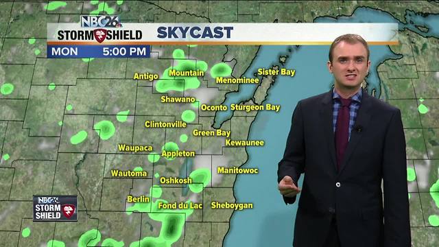
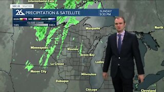
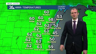
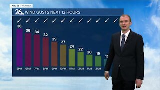
The showers and storms popped up once again in Northeast Wisconsin for the 3rd consecutive day. Some of these storms did produce pea to penny size hail, causing the ground to turn white by storm drains and gutters. The storms will gradually erode later this evening. High temperatures were in the upper 70s and lower 80s. Tonight, temperatures will cool off into the upper-50s to near 60 degrees. Winds will turn calm which could cause some patchy fog overnight. Tuesday will be mostly sunny for a lot of us, however there is the small potential of another isolated afternoon shower. Highs will top out in the low-80s. There will be a risk of showers and thunderstorms on the day Wednesday as a cold front moves through. We will begin on the sunny side of things but by the afternoon and evening, the clouds and storms will move in from the west. The cold front will move through overnight and we do have the potential of a few showers or storms for hte first have on Thursday.
-
 3:36
3:36
WGBA
1 year agoWill it be necessary to have both the AC & the heat on during the same day??
3931 -
 3:33
3:33
WGBA
4 years agoGino Recchia NBC26 Weather Forecast
3 -
 3:26
3:26
WGBA
4 years agoGino Recchia NBC26 Weather Forecast
6 -
 3:19
3:19
WGBA
4 years agoGino Recchia NBC26 Weather Forecast
4 -
 3:42
3:42
WGBA
4 years agoGino Recchia NBC26 Weather Forecast
5 -
 3:23
3:23
WGBA
4 years agoGino Recchia NBC26 Weather Forecast
7 -
 3:35
3:35
WGBA
4 years agoGino Recchia NBC26 Weather Forecast
4 -
 3:25
3:25
WGBA
4 years agoGino Recchia NBC26 Weather Forecast
13 -
 3:13
3:13
WGBA
4 years agoGino Recchia NBC26 Weather Forecast
7 -
 3:14
3:14
WGBA
4 years agoGino Recchia NBC26 Weather Forecast
3