Michael Fish's NBC26 Storm Shield weather forecast
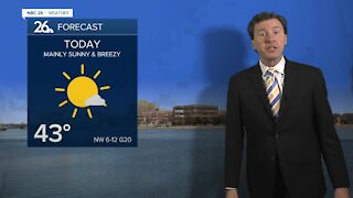
Today, a more significant weather-maker will be on the way. This could trigger an afternoon T'storm, but most of the activity looks to hold off until the nighttime. It'll be warm again with highs in the mid-80s. Tonight's threat of severe weather all depends on how humid it gets, and how much sunshine we actually see during the day today. Scattered showers and T'storms will be moving through parts of the area tonight as that cold front pushes through. A few storms could be on the strong side with some gusty wind or hail being the main threat. Most of this activity should wrap up before midnight. Lows will bottom out in the low-60s. Get ready for some cooler, drier air on Thursday & Friday with highs only in the low- to mid-70s. With some even colder air aloft, we could also see a few hit-or-miss afternoon showers. Saturday looks like a relatively nice, normal day with highs near 80. There will be a chance of a shower or T'storm on Sunday, but it will not be a wash with highs in the upper-70s.
-
 1:45
1:45
WGBA
11 months agoFond du Lac Cardinals start the football season with a new $5.3 million nest
184 -
 2:33
2:33
WGBA
3 years agoMichael Fish's NBC 26 weather forecast
4 -
 2:19
2:19
WGBA
3 years agoMichael Fish's NBC 26 weather forecast
3 -
 2:26
2:26
WGBA
3 years agoMichael Fish's NBC 26 weather forecast
4 -
 2:27
2:27
WGBA
3 years agoMichael Fish's NBC 26 weather forecast
4 -
 2:24
2:24
WGBA
3 years agoMichael Fish's NBC 26 weather forecast
3 -
 1:57
1:57
WGBA
3 years agoMichael Fish's NBC 26 weather forecast
2 -
 2:31
2:31
WGBA
3 years agoMichael Fish's NBC 26 weather forecast
7 -
 1:50
1:50
WGBA
3 years agoMichael Fish's NBC 26 weather forecast
4 -
 2:27
2:27
WGBA
3 years agoMichael Fish's NBC 26 weather forecast
1