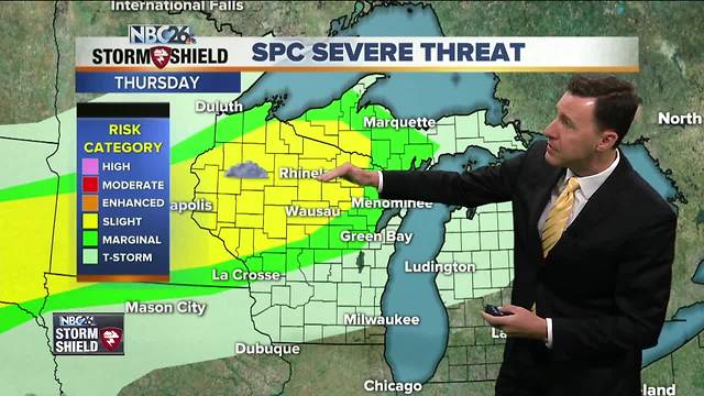
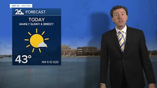
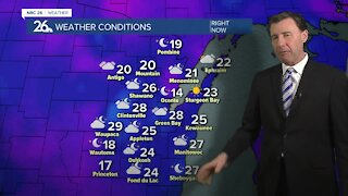
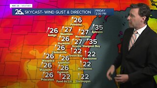
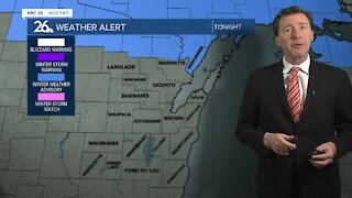
Michael Fish's NBC26 Storm Shield weather forecast
Today we have a weak frontal boundary approaching the area from the NW. The first dying complex of showers may just clip the area today, especially the farther north you live. It'll bring some clouds, but then we'll probably see more sun again as the afternoon wears on. Some storm redevelopment will be possible late in the day mainly off to the NW. We may have to keep an eye on a few of those if the atmosphere becomes too unstable. Highs will top out in the mid-80s with plenty of humidity moving in. That front pushes into the area tonight, then stalls out giving what will be an unsettled, but tricky weather pattern to forecast over the next several days. Either way, scattered T'storms will be pushing into parts of the area as the night wears on. Some of these could be a little stronger mainly off to the NW in the evening. Anyone who would be under any of these storms through the night could see some locally heavy rainfall. Lows will be warm and muggy in the low-70s. That frontal boundary is going to hang out around the area on Friday bringing us another chance of a few showers or a T'storm. It won't be an all-day rain by any means. It'll be warm and muggy again with highs in the mid- to upper-80s. The weekend looks very warm & humid with highs in the upper-80s to near 90. Even though the weekend will not be a wash, we could see a shower ot T'storm on both Saturday and Sunday with that pesky frontal boundary hanging around. As we go into Monday, a cool front will finally sweep through the area, bringing a T'storm with it. Tuesday will be much more comfortable with highs in the upper-70s and sunshine.
-
 1:57
1:57
WGBA
1 year agoHow the City of Green Bay is hoping a $1.6M investment will make the community safer for pedestrians
3822 -
 2:27
2:27
WGBA
4 years agoMichael Fish's NBC 26 weather forecast
4 -
 2:31
2:31
WGBA
4 years agoMichael Fish's NBC 26 weather forecast
7 -
 1:50
1:50
WGBA
4 years agoMichael Fish's NBC 26 weather forecast
4 -
 2:27
2:27
WGBA
4 years agoMichael Fish's NBC 26 weather forecast
1 -
 2:42
2:42
WGBA
4 years agoMichael Fish's NBC 26 weather forecast
3 -
 2:02
2:02
WGBA
4 years agoMichael Fish's NBC 26 weather forecast
3 -
 2:23
2:23
WGBA
4 years agoMichael Fish's NBC 26 weather forecast
6 -
 2:19
2:19
WGBA
4 years agoMichael Fish's NBC 26 weather forecast
2 -
 2:27
2:27
WGBA
4 years agoMichael Fish's NBC 26 weather forecast
5