NBC26 Storm Shield weather forecast
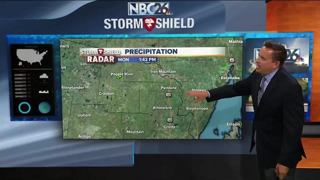
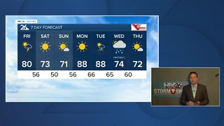
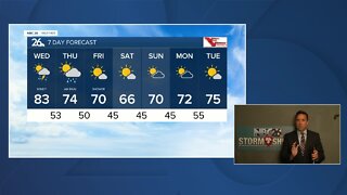
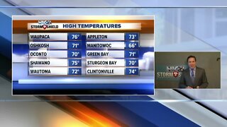
The heat and humidity are back today ahead of a weak cool front that's going to work its way on through. With this frontal boundary, we'll have some clouds and just a slight chance of an isolated T'storm. Basically, if you'd see anything in the way of rain, it would be brief with the best chances of this during the afternoon. It'll be a warm one out there with highs in the upper-80s. If there is a lingering T'storm in the early evening, that's going to end and the skies will clear out. We'll have the humidity slowly dropping as the night wears on. Lows will be in the low-60s. Tuesday will still be on the warm side, but it will be less humid. Expect plenty of sunshine with highs in the mid-80s, though cooling down along Lake Michigan. Tuesday night looks clear and quiet with lows in the upper-50s. Wednesday will be warm again with sun and highs in the mid-80s. Chances of T'storms return mainly on Thursday and Thursday night.
-
 0:30
0:30
WGBA
1 year agoThree Degree Guarantee
234 -
 3:24
3:24
WGBA
4 years agoNBC26 Storm Shield Forecast
6 -
 3:24
3:24
WGBA
4 years agoNBC26 Storm Shield Forecast
8 -
 1:29
1:29
WGBA
4 years agoNBC26 Storm Shield Forecast
7 -
 4:01
4:01
WGBA
4 years agoNBC26 Storm Shield Forecast
15 -
 3:38
3:38
WGBA
4 years agoNBC26 Storm Shield Forecast
12 -
 3:17
3:17
WGBA
4 years agoNBC26 Storm Shield Forecast
11 -
 1:32
1:32
WGBA
4 years agoNBC26 Storm Shield Forecast
4 -
 3:35
3:35
WGBA
4 years agoNBC26 Storm Shield Forecast
7 -
 3:51
3:51
WGBA
4 years agoNBC26 Storm Shield Forecast
7