NBC26 Storm Shield weather forecast
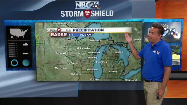
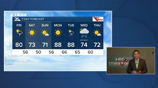
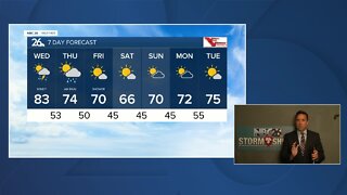
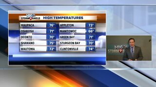
We finally have some relief from the hot and humidity today after a long stretch of temperatures in the 80s and 90s coupled with dew points in the upper 60s and lower 70s making heat index values in the mid-90s to mid-100s. High pressure is moving right over the Midwest and that is going to give us some very comfortable weather on this Friday. Sunny skies with light winds out of the north and northeast will be prevalent across Northeast Wisconsin. Temperatures will be in the lower to mid-70s along the lakeshore. Further inland, highs in the mid and upper 70s are expected. High pressure will shift to the east for the weekend. This is going to change the wind flow and gradually warm out temperatures into the lower and mid 80s for Saturday and then back into the mid and upper 80s for Sunday. The sunshine does remain in place though so no rainfall is in the forecast. There is a cold front that will be moving through our area on Monday. We could see an isolated shower or thunderstorm but it appears the font will lose steam as it moves in from Minnesota. Another high pressure returns behind it with more sunshine on Tuesday. Temperatures are expected to remain above average for the next 6 of the 7 days.
-
 1:45
1:45
WGBA
1 year agoStudents excited to start at "huge and beautiful" Vel Phillips Middle School
387 -
 3:24
3:24
WGBA
5 years agoNBC26 Storm Shield Forecast
6 -
 3:24
3:24
WGBA
5 years agoNBC26 Storm Shield Forecast
8 -
 1:29
1:29
WGBA
5 years agoNBC26 Storm Shield Forecast
7 -
 4:01
4:01
WGBA
5 years agoNBC26 Storm Shield Forecast
15 -
 3:38
3:38
WGBA
5 years agoNBC26 Storm Shield Forecast
12 -
 3:17
3:17
WGBA
5 years agoNBC26 Storm Shield Forecast
11 -
 1:32
1:32
WGBA
5 years agoNBC26 Storm Shield Forecast
4 -
 3:35
3:35
WGBA
5 years agoNBC26 Storm Shield Forecast
7 -
 3:51
3:51
WGBA
5 years agoNBC26 Storm Shield Forecast
7