Michael Fish's NBC26 Storm Shield weather forecast
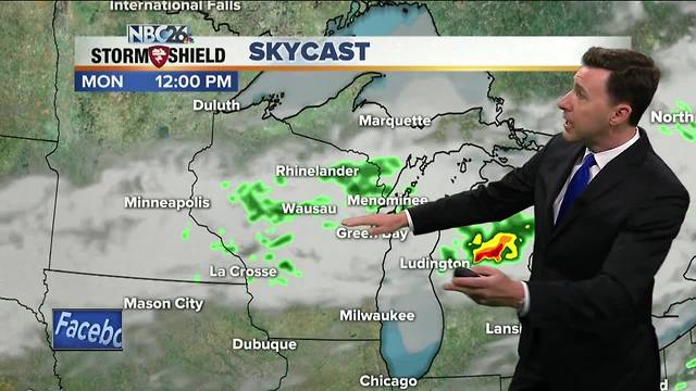
moving so slowly, rounds of T'storms will be affecting many locations with some heavier downpours. This activity will become more scattered as the late morning and afternoon approaches, but with the front still in the area, we may redevelop some more T'storms as the afternoon wears on. Highs will top out in the upper-70s, and possibly even warmer south. Tonight, if there is a lingering shower or T'storm, it should push south of the area. The humidity will be dropping with lows in the upper-50s. There will be another weak low pressure passing Tuesday giving us the chance of a few scattered showers or an isolated T'storm. It will not be as heavy as the last round. It'll also be cooler and more comfortable with highs in the mid-70s, though cooler along Lake Michigan. If there is an shower lingering into Tuesday evening, that's going to end. Lows will be in the mid-50s. Wednesday through Friday look quiet with highs in the upper-70s to near 80.
-
 1:57
1:57
WGBA
1 year agoHow the City of Green Bay is hoping a $1.6M investment will make the community safer for pedestrians
4682 -
 2:02
2:02
WGBA
4 years agoMichael Fish's NBC 26 weather forecast
3 -
 2:23
2:23
WGBA
4 years agoMichael Fish's NBC 26 weather forecast
6 -
 2:19
2:19
WGBA
4 years agoMichael Fish's NBC 26 weather forecast
2 -
 2:27
2:27
WGBA
4 years agoMichael Fish's NBC 26 weather forecast
5 -
 2:34
2:34
WGBA
4 years agoMichael Fish's NBC 26 weather forecast
2 -
 2:39
2:39
WGBA
4 years agoMichael Fish's NBC 26 weather forecast
8 -
 1:42
1:42
WGBA
4 years agoMichael Fish's NBC 26 weather forecast
6 -
 2:15
2:15
WGBA
4 years agoMichael Fish's NBC 26 weather forecast
9 -
 1:47
1:47
WGBA
4 years agoMichael Fish's NBC 26 weather forecast
3