Michael Fish's NBC26 Storm Shield weather forecast
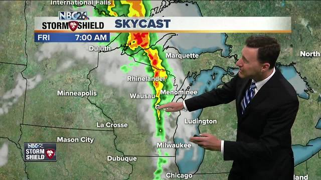
Today should be a quiet day with a few passing clouds. It will be warmer today, but the humidity will be kept in check. Highs will top out in the low-80s, but it'll be cooler near Lake Michigan. Tonight, most of the night should be okay, but overnight there's a going to be a slight chance of a T'storm with a warm front approaching. Overnight lows will be near 60. Friday, that warm front is going to be sliding its way north. It could be a little stormy at times with a chance of a shower or T'storm in the morning with some locally heavy downpours, then another chance of T'storms redeveloping as the afternoon wears on. You're going to notice the humidity on the increase. If we get enough breaks of sun, we could pop up to 80, though it'll be cooler lakeside. The chance of showers and T'storms will continue Friday night with lows in the upper-60s. The weekend's weather is going to really depend on where the stationary front sets up. Right now, it looks like it's going to make its way off to the north. That would mean most of us could see just a morning shower or T'storm, then it'll become hot and humid with highs near 90. Well north, you could redevelop a T'storm if the front is close enough. If that front is still close enough of Sunday, there will be a continued slight chance of a shower or T'storm, but otherwise it will still be hot and humid with highs in the low-90s. Chances of storms continue into Monday as a cold front slowly slides through.
-
 3:36
3:36
WGBA
1 year agoWill it be necessary to have both the AC & the heat on during the same day??
3791 -
 2:23
2:23
WGBA
4 years agoMichael Fish's NBC 26 weather forecast
6 -
 2:19
2:19
WGBA
4 years agoMichael Fish's NBC 26 weather forecast
2 -
 2:27
2:27
WGBA
4 years agoMichael Fish's NBC 26 weather forecast
5 -
 2:34
2:34
WGBA
4 years agoMichael Fish's NBC 26 weather forecast
2 -
 2:39
2:39
WGBA
4 years agoMichael Fish's NBC 26 weather forecast
8 -
 1:42
1:42
WGBA
4 years agoMichael Fish's NBC 26 weather forecast
6 -
 2:15
2:15
WGBA
4 years agoMichael Fish's NBC 26 weather forecast
9 -
 1:47
1:47
WGBA
4 years agoMichael Fish's NBC 26 weather forecast
3 -
 2:24
2:24
WGBA
4 years agoMichael Fish's NBC 26 weather forecast
5