NBC26 Storm Shield Weather Forecast
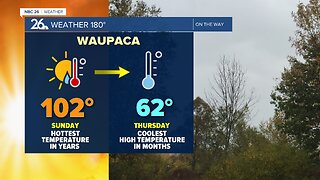
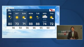
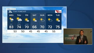
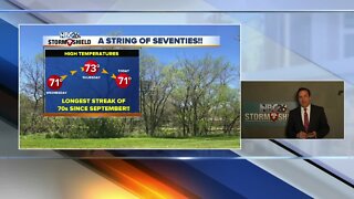
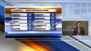
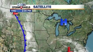
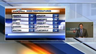
Tuesday was the 5th straight day with a high of 85° or warmer. It's the first time that has ever happened during the month of May. Wednesday will not be day #6 because our hot weather is about to turn tropical!! The remnants of "Alberto" will be headed our way for Wednesday. With it, areas of showers and embedded T'storms will be heading into the area. With plenty of available moisture with this system, we could see some locally heavy downpours should you end up under one of these showers. Highs tomorrow will be in the lower 70s with cooler readings lakeside. These occasional showers and embedded T'storms will continue as we head through Wednesday night. Lows will be in the low-60s. Thursday, the remnants of "Alberto" will be slowly departing. On the backside of it, we still could see a scattered shower or T'storm, but there should be less coverage as Wednesday and Wednesday night. Highs will be pretty warm again with highs in the mid 80s to around 90°. Friday, we'll be cooling things down, but it should be quiet with highs struggling to make it to 70. Gusty NE winds will keep it cooler near the Lake & Bay. Most of the weekend looks okay with a slight chance of a shower Saturday night. Highs Saturday will be in the low-70s and it looks like upper 70s to lower 80s for Sunday.
-
 3:36
3:36
WGBA
9 months agoWill it be necessary to have both the AC & the heat on during the same day??
1631 -
 3:24
3:24
WGBA
4 years agoNBC26 Storm Shield Forecast
6 -
 3:24
3:24
WGBA
4 years agoNBC26 Storm Shield Forecast
8 -
 1:29
1:29
WGBA
4 years agoNBC26 Storm Shield Forecast
7 -
 4:01
4:01
WGBA
4 years agoNBC26 Storm Shield Forecast
15 -
 3:38
3:38
WGBA
4 years agoNBC26 Storm Shield Forecast
12 -
 3:17
3:17
WGBA
4 years agoNBC26 Storm Shield Forecast
11 -
 1:32
1:32
WGBA
4 years agoNBC26 Storm Shield Forecast
4 -
 3:35
3:35
WGBA
4 years agoNBC26 Storm Shield Forecast
7 -
 3:51
3:51
WGBA
4 years agoNBC26 Storm Shield Forecast
7