Premium Only Content

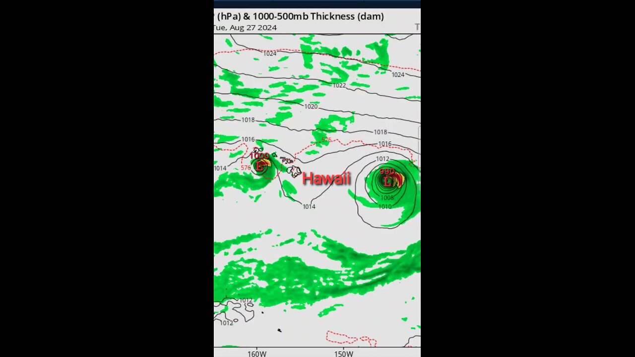
Hawaii, DOUBLE HURRICANE Gilma, Tropical Invests: 91E, 90E headed your way!
National Hurricane Center is issuing advisories on Tropical
Storm Gilma, located several hundred miles southwest of the southern
tip of the Baja California peninsula.
1. Well East-southeast of the Hawaiian Islands (EP90/EP91):
A large area of disorganized showers and thunderstorms is
associated with two disturbances over the western portion of the
East Pacific basin. These systems are expected to merge later today
or tonight, and gradual development is expected after they merge.
A tropical depression is likely to form within the next couple of
days while the disturbance moves west-northwestward into the
Central Pacific basin Wednesday night or early Thursday.
Information on this system's development can also be found in the
Tropical Weather Outlook for the Central Pacific basin.
* Formation chance through 48 hours...high...80 percent.
* Formation chance through 7 days...high...80 percent.
2. Eastern and Central Portion of the East Pacific:
An area of low pressure is expected to form well to the south of the
southwestern coast of Mexico in a couple of days. Environmental
conditions should support slow development thereafter, and a
tropical depression could form late this week or over the weekend
while the system moves west-northwestward over open waters, well
offshore of Mexico.
* Formation chance through 48 hours...low...near 0 percent.
* Formation chance through 7 days...medium...40 percent.
The Tropical Weather Outlook for the Central Pacific basin can be
found under AWIPS header HFOTWOCP and WMO header ACPN50 PHFO and on
the web at hurricanes.gov
Forecaster Cangialosi
HURRICANE GILMA brings more tropical waves to EPAC #Gilma #TropicalstormsCorrect depression to Gilma in the motion section
...DEPRESSION STRENGTHENS TO #TROPICALSTORMGILMA
#HURRICANEGILMA #GILMA #EPAC #PACIFICOCEAN #bajacalifornia
SUMMARY OF 200 PM MST...2100 UTC...INFORMATION
----------------------------------------------
LOCATION...14.7N 112.3W
ABOUT 585 MI...945 KM SSW OF THE SOUTHERN TIP OF BAJA CALIFORNIA
MAXIMUM SUSTAINED WINDS...40 MPH...65 KM/H
PRESENT MOVEMENT...W OR 280 DEGREES AT 12 MPH...19 KM/H
MINIMUM CENTRAL PRESSURE...1005 MB...29.68 INCHES
#BERMUDA #HURRICANE
A Hurricane Warning is in effect for...
* Bermuda
Bermuda braces for DIRECT IMPACT #LARGE ERNESTO EXPECTED TO BRING #BERMUDA STRONG WINDS, DANGEROUS
STORM SURGE, AND LIFE-THREATENING FLOODING LATER TODAY...
LARGE ERNESTO EXPECTED TO BRING BERMUDA STRONG WINDS, DANGEROUS
STORM SURGE, AND LIFE-THREATENING FLOODING LATER TODAY...
HURRICANE WARNING IN EFFECT FOR BERMUDA...
...HIGH RISK OF DANGEROUS RIP CURRENTS ALONG U.S. EAST COAST BEACHES
THIS WEEKEND...
ERNESTO BECOMES A HURRICANE NORTH OF PUERTO RICO...
...SIGNIFICANT FLOODING LIKELY ACROSS PUERTO RICO AND THE VIRGIN
ISLANDS AS HEAVY RAINS PERSIST...
WATCH REAL LIFE SUPER HEROES
https://youtu.be/lSLrlQlokN4
#coldfront #hot #heat #category3 #atlantic #atlanticocean
NOW #moving over Puerto Ricoand #VirginIslands #CAT3 #BERMUDA
The government of Antigua and Barbuda has issued a Hurricane Watch #weatherreport #weatherupdate
for the British Virgin Islands.#Hurricane #Hurricanes #tropicalcyclone #tropical #tropics #tropicalstorm #tropicalstormernesto #hurricaneernesto #rain #flood #surge #wind #debby #tiffanyscontent #weather #meterologist #storms #stormdamage #watch #Caribbean #puertorico #turksandcaicos #TiffanysContent #turksandcaicosislands #Haiti #Bermuda #caribbeanisland #meterologist #thunderstorms #lightning #DominicanRepublic #VirginIslands #rainfall #rain #thunderstorm #Ernesto #hurricaneernesto #tropicalstormernesto
sources
www.nhc.noaa.gov
www.hurricane.gov
www.zoom.earth.com
www.pivotalweather.com
#WATCHES AND #WARNING
--------------------
A #TropicalStormWarning is in effect for...
* #SaintKitts #Nevis #Montserrat #Antigua , #Barbuda and Anguilla
#Guadeloupe
#SaintMartin and St. Barthelemy
#SintMaarten
#BritishIslands
* #usa #VirginIslands
* #PuertoRico
* #Vieques
* #Culebra
-
 1:20:04
Tim Pool
4 days agoGame of Money
53.8K10 -
 2:21:11
Nerdrotic
11 hours ago $25.29 earnedDown the Rabbit Hole with Kurt Metzger | Forbidden Frontier #090
104K21 -
 2:41:13
vivafrei
16 hours agoEp. 251: Bogus Social Security Payments? DOGE Lawsduit W's! Maddow Defamation! & MORE! Viva & Barnes
232K264 -
 1:19:23
Josh Pate's College Football Show
9 hours ago $3.88 earnedBig Ten Program Rankings | What Is College Football? | Clemson Rage| Stadiums I Haven’t Experienced
60.7K1 -
 LIVE
LIVE
Vigilant News Network
15 hours agoBombshell Study Reveals Where the COVID Vaccine Deaths Are Hiding | Media Blackout
1,949 watching -
 1:17:59
Sarah Westall
10 hours agoDOGE: Crime & Hysteria bringing the Critics & the Fearful - Plus new CDC/Ukraine Crime w/ Dr Fleming
56.2K3 -
 45:39
45:39
Survive History
16 hours ago $9.19 earnedCould You Survive in the Shield Wall at the Battle of Hastings?
64.4K6 -
 1:50:28
TheDozenPodcast
15 hours agoViolence, Abuse, Jail, Reform: Michael Maisey
101K4 -
 23:01
23:01
Mrgunsngear
1 day ago $5.94 earnedWolfpack Armory AW15 MK5 AR-15 Review 🇺🇸
86.9K12 -
 25:59
25:59
TampaAerialMedia
1 day ago $3.75 earnedUpdate ANNA MARIA ISLAND 2025
55.2K4