FLORIDA LANDFALL TROPICAL STORM, Carolinas viable HURRICANE DEBBIE cat2: 110mph
FLORIDA LANDFALL, TROPICAL STORM Carolinas viable HURRICANE DEBBIE : Cat2 110mph Active Systems:
The National Hurricane Center is issuing advisories on Potential
Tropical Cyclone Four, located over eastern Cuba.
* Formation chance through 48 hours...high...80 percent.
* Formation chance through 7 days...high...90 percent.
Tropical cyclone formation is not expected during the next 7 days.
&&
Public Advisories on Potential Tropical Cyclone Four are issued
under WMO header WTNT34 KNHC and under AWIPS header MIATCPAT4.
Forecast/Advisories on Potential Tropical Cyclone Four are issued
under WMO header WTNT24 KNHC and under AWIPS header MIATCMAT4.
$$
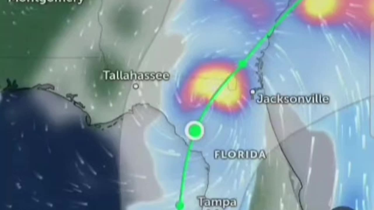
Forecaster Papin#Saturday Environmental conditions are expected to be #conducive for additional
development after that time, and a #tropical depression is likely to form this #weekend over the Straits of Florida or eastern #Gulf of
Mexico near the Florida Peninsula. #NorthCarolina #southcarolina
Tropical storm #watches or #warnings could be required for portions of Florida later today.
Active Systems:
The National Hurricane Center is issuing advisories on Potential
Tropical Cyclone Four, located over eastern Cuba.
* Formation chance through 48 hours...high...80 percent.
* Formation chance through 7 days...high...90 percent.
Tropical cyclone formation is not expected during the next 7 days.
&&
Public Advisories on Potential Tropical Cyclone Four are issued
under WMO header WTNT34 KNHC and under AWIPS header MIATCPAT4.
Forecast/Advisories on Potential Tropical Cyclone Four are issued
under WMO header WTNT24 KNHC and under AWIPS header MIATCMAT4.
$$
Forecaster Papin
Regardless of development, heavy rains could cause areas of flash #atlantic #atlanticocean
flooding across Florida, Cuba, and the Bahamas through the weekend,
and interests in these locations should continue to monitor the
progress of this system. A #NOAA Hurricane Hunter #aircraft is
scheduled to investigate this system later today.
* Formation chance through 48 hours...medium...60 percent.
* Formation chance through 7 days...high...90 percent.Southwestern Atlantic and Eastern #GulfofMexico:
A well-defined tropical wave is producing a large area of
disorganized showers and thunderstorms over #Hispaniola #PuertoRico the #VirginIslands and the adjacent waters of the
southwestern Atlantic and northeastern #Caribbean Sea. Development of
this system should be slow to occur during the next couple of days
while it moves west-northwestward over portions of the Greater
Antilles. However, environmental conditions are forecast to be more
conducive for development after the #tropicalwave passes the Greater
#Antilles and a tropical depression could form this weekend or early
next week over the eastern Gulf of Mexico or near the #FloridaPeninsula Interests across the Greater Antilles, the #Bahamas and
Florida should continue to monitor the progress of this system.
* Formation chance through 48 hours...low...20 percent.
* Formation chance through 7 days...medium...60 percent.
#Forecaster Beven
#Hurricane #Hurricanes #tropicalstorm #storms #tropicalwaves #thunderstorms #rainfall #rain #weather #flooding #forecast #TiffanysContent #heat #hot #Hurricaneseason #tropics #tropicalstorms #tropical #formation #hurricaneberyl #hurricanecarlotta #carlotta #Pacific ##gulfofmexico #tropicalcyclone #atlantic #tropicaldepression #epac #carlotta #Florida #tampa #miami #orlando #Jacksonville #crystaleiver #Puertorico #bahamas #cedarkey #floridapanhandle #hurricaneberyl #Beryl #winds #wind #florida #jacksonville #tropicalcyclone #forecast #severe #flooding #storms #rain #flooding #Mexico #cuba #carlotta #Florida, Starts THIS WEEKEND⚠️🚨 ENTIRE FLORIDA ON ALERT! Where's it going? #tropicalstorm #hurricane
-
 1:24:56
Glenn Greenwald
5 hours agoGlenn Takes Your Questions on Tulsi's Russiagate Revelations, Columbia's $200M Settlement, and More | SYSTEM UPDATE #492
94.1K44 -
 LIVE
LIVE
megimu32
2 hours agoOTS: With Great Power: Every Spider-Man Movie Unmasked w/ @thisistheraygaming
116 watching -
 LIVE
LIVE
WickedVirtue
1 hour agoSailing w/ The Crew
76 watching -
 LIVE
LIVE
Meisters of Madness
4 hours agoThe Finals with Redd
96 watching -
 1:27:11
Omar Elattar
9 hours agoThe Dating Expert: "I've Helped 4,000 Men Find LOVE!" - The #1 Alpha Trait Women Secretly Crave!
20K -
 LIVE
LIVE
VOPUSARADIO
9 hours agoPOLITI-SHOCK! "END THE FED, END THE LIES & END THE DEEP STATE ONCE AND FOR ALL"!
162 watching -
 1:43:38
LumpyPotatoX2
5 hours agoRumble Creator Round-Table - Let's Talk About It
22.2K2 -
 32:38
32:38
The Mel K Show
7 hours agoMel K & Dr. James Thorp, MD | Sacrifice: The Targeting of the Most Vulnerable | 7-24-25
27.6K10 -
 1:12:41
Donald Trump Jr.
6 hours agoFrom Crypto to AI, There's a New American Energy Revival, Interviews with Asher Genoot & Sen McCormick | TRIGGERED Ep.261
155K53 -
 52:11
52:11
ZeeeMedia
9 hours ago"Meaningful Deep State Prosecution" ft. Robert Barnes | Daily Pulse Ep. 73
38.5K8