Where is your Flat Earth Map?! 🤣
Where is your Flat Earth Map?! 🤣
🤣
Addressed. Once and for all
Perhaps now you may understand why I always start with....
WELL.......
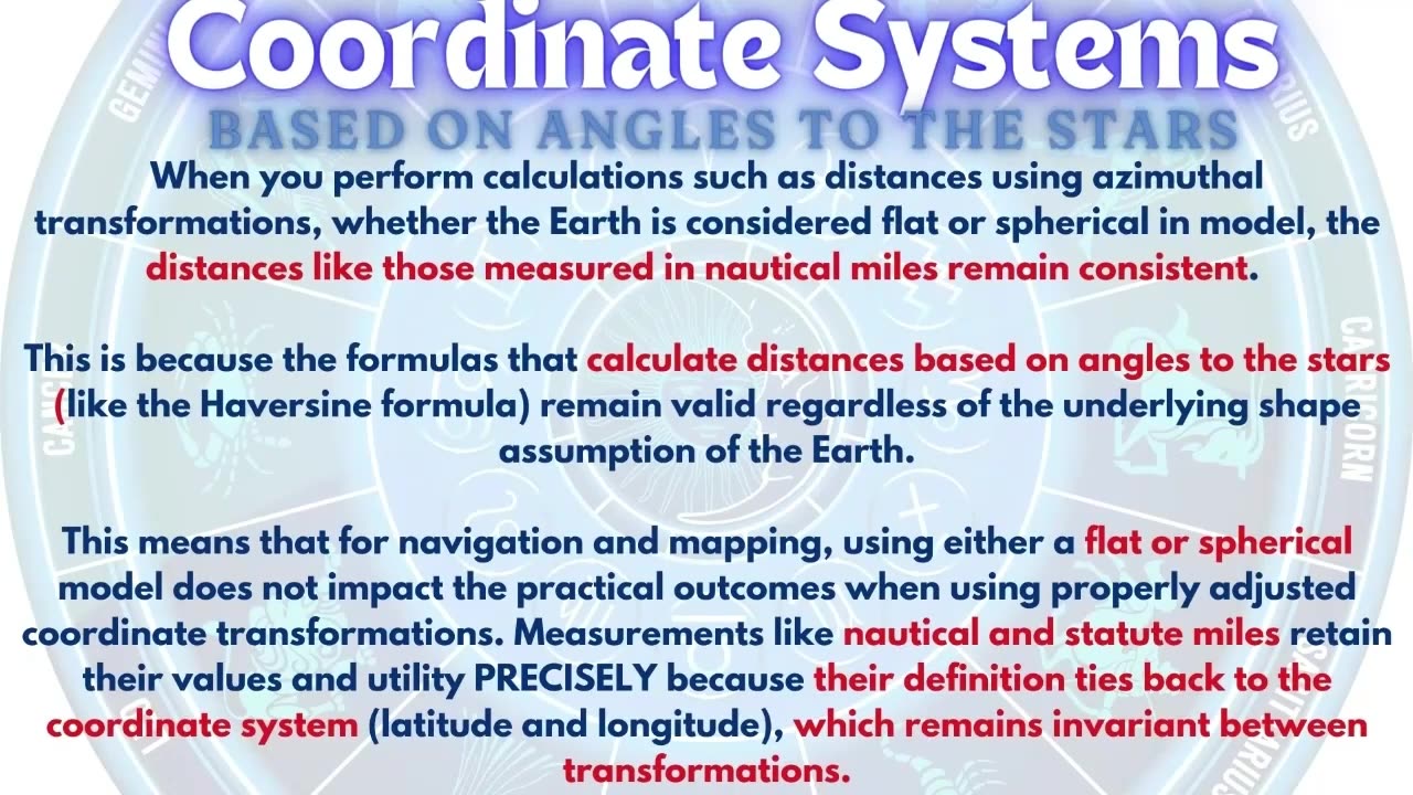
What do all worldwide maps project?
All maps project a coordinate system onto a flat surface. The most commonly used coordinate system is the geographic coordinate system, which models the Earth as a sphere or ellipsoid. This requires a predetermined spherical datum to tie the coordinate system to the actual earth. Most common is wgs84.
This system uses a spherical latitude and longitude system known as the graticule to specify locations on the Earth’s surface. Different map projections then transform these spherical coordinates into a two-dimensional representation, each with its own set of compromises regarding area, shape, distance, and direction.
2) How is latitude determined?
Latitude is determined by measuring the angle between the horizon and a known celestial object,
such as the Sun at its highest point (noon) or Polaris (the North Star) at night. This angle corresponds directly to the latitude of the observer. For example, if Polaris is 30 degrees above the horizon, the observer is at approximately 30 degrees North latitude.
3) How is longitude measured - what observations were crucial in establishing the farthest southern longitudes, as requested by the Board of Longitude in 1714?
Since The geographic coordinate system relies on the positions of celestial bodies to determine latitude and longitude, Taking angles to the stars at various longitudes was a fundamental aspect of properly mapping and refining the geographic coordinate system. They supposedly studied the variations of the night sky, as different stars become visible, and the lunar values - the angular distance between the Moon and a specific star - then compared them with distances listed in the nautical almanac.
4) What are the resultant differences in geodesic surveying, commonly referred to as 'deflection of the vertical', used for in regard to celestial navigation?
The deflections of the vertical are critical for accurate celestial navigation and are accounted for in various ways, including through the use of ephemerides and navigational almanacs.
They incorporate the deflections of the vertical to adjust the observed altitude. The deflections of the vertical are critical for precise celestial navigation. While they are not directly added to the almanac or ephemeris, correction tables or algorithms are used to adjust observed celestial altitudes. These corrections ensure accurate navigation by accounting for local gravitational anomalies, enhancing the reliability of positional data derived from celestial observations. Modern navigational systems and digital tools integrate these corrections
automatically, streamlining the process for navigators.
5) What are any of the 3 stated purposes of astrogeodetic surveying based on? [Based on the document "The Use and Abuse of Vertical Deflections,"]
Transformation of Astronomica
-
 12:54
12:54
Anti-Disinfo League
19 days agoMaps on Flat Earth in 10 minutes
4511 -
 2:09:29
Tim Pool
2 hours agoEXPOSING Secret Government Tech, UFOs & TELEPORTATION | The Culture War with Tim Pool
140K58 -
 LIVE
LIVE
The Charlie Kirk Show
1 hour agoDouble SCOTUS Victory + AMA | Mailman, Sen. Mullin | 6.27.25
4,254 watching -
 LIVE
LIVE
The Big Mig™
1 hour agoGlobal Finance Forum From Bullion To Borders We Cover It All
78 watching -
 LIVE
LIVE
Rebel News
44 minutes agoGazan refugees to Canada, Canadian dies in ICE custody, Pro-Iran protests in Toronto | Rebel Roundup
332 watching -
 LIVE
LIVE
Tudor Dixon
57 minutes agoThe China Factor: What They’re Not Telling Us About 2020 with John Solomon | The Tudor Dixon Podcast
94 watching -
 1:16:27
The White House
2 hours agoPresident Trump Holds a Press Briefing, June 27, 2025
9.91K30 -
 1:20:51
Steven Crowder
4 hours agoBREAKING: Supreme Court Decision Hands Trump a Major W & Can Communism be a Good Thing
166K103 -
 LIVE
LIVE
Flyover Conservatives
12 hours agoHow to 10X Your Website Conversions: 5-Step Conversion Formula - Clay Clark | FOC Show
619 watching -
 58:25
58:25
The Rubin Report
5 hours agoNYC Mayor Has a Brutal Message for Zohran Mamdani
26.7K35