Michael Fish's NBC26 Storm Shield weather forecast
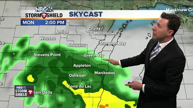
We have a weak area of low pressure passing to our south today, and with it, some areas of showers. These should move in as the day goes on, especially into the afternoon. The farther north you live, the lesser your chance of seeing some of this rain. Either way, this will not be a big rain-maker, though if you'd hear an isolated rumble of thunder, don't be surprised. Highs will be kind of cool today with readings topping out around 60, though cooler lakeside. Tonight, if there are any leftover scattered showers, those look to end as the night wears on. Lows will be in the mid-40s. Tuesday does look to improve as the day goes on. After a slight chance of a morning shower, clouds will gradually start to break, especially in the afternoon. Our highs will be close to average with readings topping out in the upper-60s, though cooler along Lake Michigan. Tuesday night should be mostly clear and dry. Lows will be in the low-50s. Wednesday looks like a pretty nice day with highs in the upper-70s, though possibly cooling down lakeside. Things become more active by Thursday, and especially Friday and Saturday with chances of showers and T'storms. It will also be warmer and a little more humid with highs either side of 80. The Fox River is experiencing minor flooding in Green Lake County. The river is expected to drop below flood stage by Thursday.
-
 0:30
0:30
WGBA
1 year agoThree Degree Guarantee
308 -
 1:47
1:47
WGBA
4 years agoMichael Fish's NBC 26 weather forecast
3 -
 2:08
2:08
WGBA
4 years agoMichael Fish's NBC 26 weather forecast
26 -
 1:52
1:52
WGBA
4 years agoMichael Fish's NBC 26 weather forecast
5 -
 1:39
1:39
WGBA
4 years agoMichael Fish's NBC 26 weather forecast
8 -
 1:44
1:44
WGBA
4 years agoMichael Fish's NBC 26 weather forecast
3 -
 2:46
2:46
WGBA
4 years agoMichael Fish's NBC 26 weather forecast
5 -
 2:30
2:30
WGBA
4 years agoMichael Fish's NBC 26 weather forecast
5 -
 2:20
2:20
WGBA
4 years agoMichael Fish's NBC 26 weather forecast
14 -
 2:21
2:21
WGBA
4 years agoMichael Fish's NBC 26 weather forecast
6