Premium Only Content

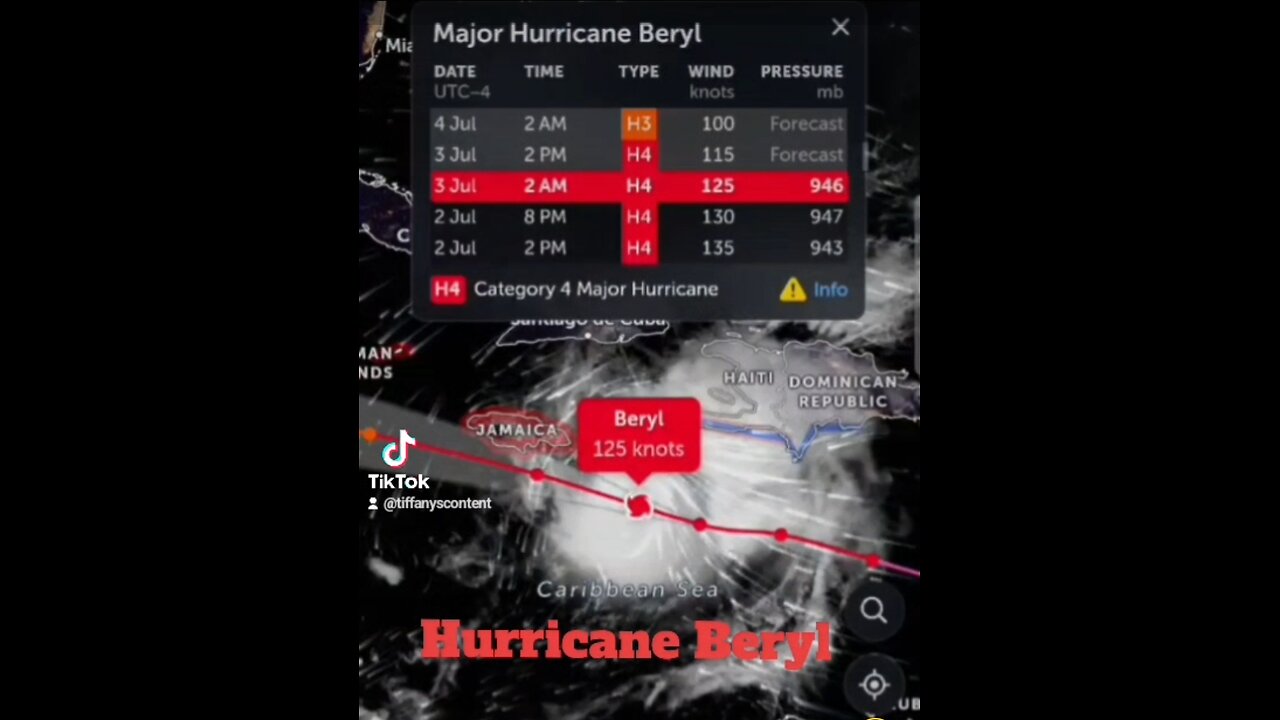
Jamaica CAT.4 HURRICANE BERYL EYE MOVING IN QUICKLY!
Maximum sustained winds are near 145 mph (230 km/h) with higher gusts. Beryl is a Category 4 hurricane on the Saffir-Simpson
Hurricane Wind Scale. Some weakening is forecast during the next
day or two. However, Beryl is forecast to be at or near major hurricane intensity while it passes near Jamaica later today and
the Cayman Islands tonight or early Thursday. Additional weakening
is expected thereafter, though Beryl is forecast to remain a hurricane in the northwestern Caribbean. #category4
Hurricane-force winds extend outward up to 45 miles (75 km) from the
center and tropical-storm-force winds extend outward up to 185 miles
(295 km).
The estimated minimum central pressure is 946 mb (27.94 inches).
DANGEROUS HURRICANE BERYL EXPECTED TO IMPACT JAMAICA
MIDDAY BRINGING LIFE-THREATENING WINDS AND STORM SURGE...
...EXPECTED TO APPROACH THE CAYMAN ISLANDS TONIGHT INTO THURSDAY...
JAMAICA; EYE OF HURRICANE BERYL MOVING IN QUICKLY! WEST-NORTHWESTWARD TO THE SOUTH OF
HISPANIOLA... #BERYL
...EXPECTED TO BRING LIFE-THREATENING #WINDS AND STORM SURGE TO
JAMAICA ON #WEDNESDAY AND THE #CAYMAN #ISLANDS WEDNESDAY #NIGHT AND
THURSDAY...
EXPECTED TO BRING LIFE-THREATENING WINDS AND STORM SURGE TO JAMAICA ON WEDNESDAY AND THE CAYMAN ISLANDS WEDNESDAY NIGHT AND THURSDAY... As of 5:00 PM EDT Tue Jul 2 the center of Beryl was located near 15.9, -70.8 with movement WNW at 22 mph. The minimum central pressure was 943 mb with maximum sustained winds of about 155 mph.
#Category4hurricane when it reaches the Windward Islands. This is a very #dangerous situation and #residents in these areas should listen to local government and #emergency management officials for any preparedness and/or evacuation orders. All preparations should be rushed to completion #today (June 30). #eye #core
#category5hurricane
Potentially catastrophic hurricane-force winds, a life-threatening #storm surge, and damaging waves are expected when #Beryl passes over portions of the #WindwardIslands with the highest risk of the core in #SaintVincent and the #Grenadines and #Grenada beginning early Monday morning. #Hurricane #Warnings are in effect for much of the Windward Islands.
Heavy #rainfall and localized #flooding are expected across the Windward Islands through #Monday #rain #hurricaneberyl #Hurricanes #hurricanewind
#jamaican
Beryl is expected to remain a powerful hurricane as it moves across the #Caribbean #Sea later this week and interests in #Hispaniola #Jamaica the Cayman Islands and the remainder of the northwestern #Caribbean should monitor its progress, There is large forecast uncertainty at days 4 and 5 and users should not focus on the specific details of the track or intensity #forecast #weather #zoomearth #severe #hurricaneberyl #storm #storms #floodimg #poweroutages #power #electricity #meterologist #jamaica #DominicanRepublic #haiti #TiffanysContent #weatherreport #puertorico
-
 33:49
33:49
Quite Frankly
16 hours agoThe Christmas Eve Midnight Telethon
33.1K4 -
 2:12:46
Price of Reason
16 hours agoAmber Heard BACKS Blake Lively Lawsuit Against Justin Baldoni! Is Disney CEO Bob Iger in TROUBLE?
13.8K7 -
 1:01:17
The StoneZONE with Roger Stone
10 hours agoChristmas Edition: Why the Panama Canal is Part of the America First Agenda | The StoneZONE
77K24 -
 LIVE
LIVE
LFA TV
21 hours agoLFA TV CHRISTMAS EVE REPLAY
1,873 watching -
 4:33:48
tacetmort3m
1 day ago🔴 LIVE - THE ZONE KEEPS PULLING ME BACK - STALKER 2 - PART 15
54.4K12 -
 22:45
22:45
Brewzle
18 hours agoI Went Drinking In A Real Bourbon Castle
37.7K3 -
 48:36
48:36
PMG
1 day ago $2.69 earned"Parkland Parent Speaks Out On Kamala Harris Using Victims"
30.1K4 -
 4:06
4:06
The Lou Holtz Show
16 hours agoCoach Lou Holtz’s Heartfelt Christmas Message 🎄 | Family, Faith & Notre Dame Spirit 💚 #christmas
22.3K -
![ROSEANNE BARR - Her Journey, TRUMP, and the MAGA GOLDEN AGE! [INTERVIEW]](https://1a-1791.com/video/s8/1/M/m/B/2/MmB2v.0kob.1-small-ROSEANNE-BARR-Her-Journey-T.jpg) 51:35
51:35
Dr Steve Turley
1 day ago $19.18 earnedROSEANNE BARR - Her Journey, TRUMP, and the MAGA GOLDEN AGE! [INTERVIEW]
57.2K54 -
 57:38
57:38
The Tom Renz Show
14 hours agoMerry Christmas - The Tom Renz Show Christmas
93.4K17