another... TRIPLE THREAT!
Tropical Weather Outlook
NWS National Hurricane Center Miami FL
800 AM EDT Fri Jun 28 2024
For the North Atlantic... #CaribbeanSea and the Gulf of Mexico:
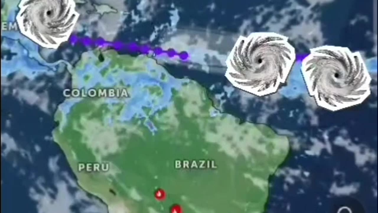
1. Western Caribbean/Southwestern #GulfofMexico (AL94):
A broad area of low pressure over the western Caribbean Sea
associated with a tropical wave continues to produce widespread
shower and thunderstorm activity. Development of this system is not
expected today while it moves west-northwestward at around 15 mph,
and an #Air Force reconnaissance mission planned for today has been
canceled. The disturbance is then expected to move westward over the
Yucatan Peninsula and emerge over the Bay of Campeche late Saturday
or early Sunday, at which point some development will be possible.
Regardless of development, heavy rainfall associated with the
tropical wave will affect portions of Central America and Mexico
through the #weekend
* Formation chance through 48 hours...low...30 percent.
* Formation chance through 7 days...low...30 percent.
2. Central #Tropical #Atlantic (AL95):
A low pressure system located about 1500 miles east-southeast of the
Windward Islands is gradually becoming better defined. Showers and
thunderstorms are also showing signs of organization, and a tropical
depression or #tropicalstorm will likely form later today or on
Saturday. This system is expected to move westward at 15 to 20 mph
and approach the Lesser #Antilles by the end of the weekend.
Interests there should monitor the progress of this system. For
more information, including gale warnings, see High Seas #Forecasts
issued by the National Weather Service.
* Formation chance through 48 hours...high...90 percent.
* Formation chance through 7 days...high...90 percent.
3. Eastern Tropical Atlantic:
A tropical wave centered several hundred miles south-southwest of
the #CaboVerde #Islands is producing disorganized showers and
thunderstorms. Some slow development of this system is possible
next week while it moves generally westward across the central
and western tropical Atlantic at 15 to 20 mph.
* Formation chance through 48 hours...low...near 0 percent.
* Formation chance through 7 days...low...20 percent.
High Seas Forecasts issued by the National Weather Service
Forecaster Cangialosi/Zelinsky
#Hurricane #tornadoes #tornado #tropicalstorm #wind #rain #weather #TiffanysContent #rainfall #ocean #islands #thunderstorms #Beryl #Hurricanes #hurricaneberyl #nhc #zoomearth #earth
www.nhc.noaa.gov
www.zoom.earth.com
-
 LIVE
LIVE
The Rubin Report
44 minutes agoBill Maher Obliterates Patton Oswalt’s Liberal Bubble in Only 2 Minutes
1,287 watching -
 LIVE
LIVE
Dr Disrespect
1 hour ago🔴LIVE - DR DISRESPECT - ARC RAIDERS - NO MERCY TO MAX LEVEL
615 watching -
 1:00:48
VINCE
2 hours agoHere Come The Epstein Files | Episode 171 - 11/18/25 VINCE
60.4K56 -
 LIVE
LIVE
LFA TV
13 hours agoLIVE & BREAKING NEWS! | TUESDAY 11/18/25
4,297 watching -
 LIVE
LIVE
Benny Johnson
1 hour ago🚨House Voting to Release Epstein Files as Trump Plan REVEALED, Democrat PANIC: ‘It Was All A Trap…’
4,895 watching -
 47:12
47:12
theoriginalmarkz
1 hour agoCoffee with MarkZ. 11/18/2025
1.46K3 -
 1:36:43
Graham Allen
3 hours agoDisturbing Connection Between Trump Shooter And FURRIES!! + House Votes To Release Epstein Files!
120K798 -
 LIVE
LIVE
Wendy Bell Radio
6 hours agoIt's All Connected.
7,316 watching -
 LIVE
LIVE
Badlands Media
4 hours agoBadlands Daily: November 18, 2025
3,914 watching -
 LIVE
LIVE
Major League Fishing
5 days agoLIVE! - Fishing Clash Team Series: Summit Cup - Day 3
121 watching