Michael Fish's NBC26 Storm Shield weather forecast
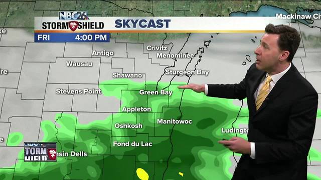
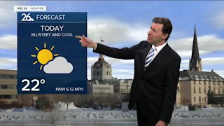
There is going to be a sharp cutoff as to who sees rain on today, and who stays dry. The farther you live to the south of Highway 29, the more rain you'll probably see. The farther north, the better your chance of staying completely dry. Gusty NE winds off of Lake Michigan will keep temps only in the 40s, which is 15-20° below normal for mid-May. This same rain scenario will continue going into tonight. The farther south you live, the more rain you'll see. Lows will bottom out in the upper-30s. It looks like that frontal boundary will continue to stay south of the area for Saturday. That means most of us should have a dry day, but if you live well to the south, you could see a few isolated showers. Either way, it's going to be kind of cool with highs in the upper-50s, but warmer north where there'd be more sunshine. Saturday night there will be a slight chance of a shower, but most of the night will be okay. Lows will botom out around 40. Mother's Day Sunday looks fairly decent with highs in the upper-60s, though it will become cooler along the lake with a lake breeze kicking in. There will be a slight chance of a shower with a weak wave rolling through, but most of the day will be fine. Warm temperatures getting close to 80 will return for Monday and Tuesday, though Tuesday there will be a chance of showers and T'storms. The Wolf River near Shiocton, & New London remain under a River Flood Warning for the time being with minor flooding currently being observed. The Fox River is experiencing minor flooding in Green Lake County.
-
 0:30
0:30
WGBA
1 year agoThree Degree Guarantee
235 -
 2:46
2:46
WGBA
3 years agoMichael Fish's NBC 26 weather forecast
5 -
 2:30
2:30
WGBA
3 years agoMichael Fish's NBC 26 weather forecast
5 -
 2:20
2:20
WGBA
3 years agoMichael Fish's NBC 26 weather forecast
14 -
 2:21
2:21
WGBA
3 years agoMichael Fish's NBC 26 weather forecast
6 -
 2:25
2:25
WGBA
3 years agoMichael Fish's NBC 26 weather forecast
4 -
 1:55
1:55
WGBA
3 years agoMichael Fish's NBC 26 weather forecast
10 -
 2:11
2:11
WGBA
3 years agoMichael Fish's NBC 26 weather forecast
4 -
 1:50
1:50
WGBA
3 years agoMichael Fish's NBC 26 weather forecast
3 -
 1:45
1:45
WGBA
3 years agoMichael Fish's NBC 26 weather forecast
7