NBC26 Storm Shield Weather Forecast
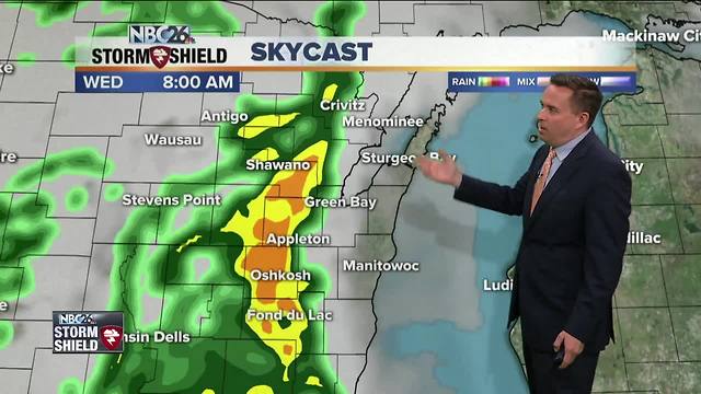
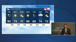
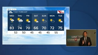
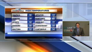
With highs in the low/mid 80s......Tuesday was the warmest days since September!! A frontal boundary will approach the area tonight. Most of the night should be quiet with just a chance for a shower or tow. Lows will be in the 50s. The chances of showers and T'storms goes way up for Wednesday!!. With clouds & the threat for rain.....highs will be much cooler with 60s expected. Rain totals could end up over 0.50", which isn't that much, but many of our waterways are full. Thursday, we should have a break with highs in the low/mid-60s. By Friday, our temperatures will only be in the 40s going right into the weekend. Rain looks to develop on Friday, and go into Saturday. There are large model disagreements with timing and strength, but this could bring some significant rain again, which could aggravate flooding concerns. Gusty NE winds off of Lake Michigan will keep temps 15-20° below normal for Mid May!! Sunday through next Tuesday looks milder and dry. The Wolf River near Shiocton, & New London remain under a River Flood Warning for the time being with minor flooding currently being observed. The Fox River is experiencing minor flooding in Green Lake County.
-
 3:36
3:36
WGBA
1 year agoWill it be necessary to have both the AC & the heat on during the same day??
3921 -
 3:24
3:24
WGBA
5 years agoNBC26 Storm Shield Forecast
6 -
 3:24
3:24
WGBA
5 years agoNBC26 Storm Shield Forecast
8 -
 1:29
1:29
WGBA
5 years agoNBC26 Storm Shield Forecast
7 -
 4:01
4:01
WGBA
5 years agoNBC26 Storm Shield Forecast
15 -
 3:38
3:38
WGBA
5 years agoNBC26 Storm Shield Forecast
12 -
 3:17
3:17
WGBA
5 years agoNBC26 Storm Shield Forecast
11 -
 1:32
1:32
WGBA
5 years agoNBC26 Storm Shield Forecast
4 -
 3:35
3:35
WGBA
5 years agoNBC26 Storm Shield Forecast
7 -
 3:51
3:51
WGBA
5 years agoNBC26 Storm Shield Forecast
7