Michael Fish's NBC26 Storm Shield weather forecast
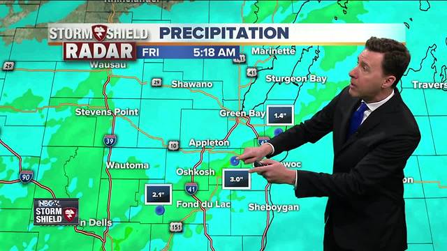
The hardest-hit areas with the heavy rainfall was a stripe from parts of Fond du Lac, Winnebago, Calumet and Manitowoc counties with an estimated 1.5-3" of rainfall on top of saturated soil. This rain will depart, then things will quiet down for today with more afternoon sunshine. With gusty WSW winds, temps will climb back up into the low-70s. Tonight will be mostly clear and quiet with lows in the upper-40s. Saturday will be warmer again with most of your daytime hours looking dry, aside from a slight chance of a T'storm in the late afternoon. Highs will top out in the mid/upper 70s, though possibly cooling just a bit near Lake Michigan at times. A cold front will be rolling through on Saturday night giving the area a chance of some scattered showers and T'storms. Lows will be in the mid-40s with the wind picking up as the night goes on. That should be out of here for most of the day Sunday, though it will be breezy and cooler. With a NE wind, it will be much cooler along Lake Michigan. Highs will only top out in the low-60s, but that's near average for this time of year. Quiet conditions will prevail for Monday and Tuesday of next week. The Wolf River near Shiocton, & New London remain under a flood warning for the time being with minor flooding currently being observed. The river level has been falling, but could rise again after last night's rain. Also, the South Branch Rock River near Waupun, there's a Flood Warning as well for the time being.
-
 1:45
1:45
WGBA
2 years agoStudents excited to start at "huge and beautiful" Vel Phillips Middle School
393 -
 2:46
2:46
WGBA
4 years agoMichael Fish's NBC 26 weather forecast
5 -
 2:30
2:30
WGBA
4 years agoMichael Fish's NBC 26 weather forecast
5 -
 2:20
2:20
WGBA
4 years agoMichael Fish's NBC 26 weather forecast
14 -
 2:21
2:21
WGBA
4 years agoMichael Fish's NBC 26 weather forecast
6 -
 2:25
2:25
WGBA
4 years agoMichael Fish's NBC 26 weather forecast
4 -
 1:55
1:55
WGBA
4 years agoMichael Fish's NBC 26 weather forecast
10 -
 2:11
2:11
WGBA
4 years agoMichael Fish's NBC 26 weather forecast
4 -
 1:50
1:50
WGBA
4 years agoMichael Fish's NBC 26 weather forecast
3 -
 1:45
1:45
WGBA
4 years agoMichael Fish's NBC 26 weather forecast
7