Michael Fish's NBC26 Storm Shield weather forecast
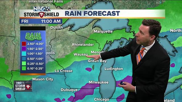
We had a cool front work through yesterday, and with those NE winds behind the front today, it.will cool thing down quite a bit form the last few days. Any morning rain moves out, then there will just be a slight chance of a shower. Basically, most of your day will be okay. Highs will be around 60. Another area of low pressure will be tracking through tonight giving many of us showers and possibly some T'storms. The threat for severe weather is low but locally heavy rain is possible, especially the farther south you live. Lows tonight will be in the upper-40s. After any lingering morning rain works out of here, things quiet down for Friday with more afternoon sunshine. With gusty WSW winds, temps will climb back up into the low-70s. Friday night will be quiet with lows in the upper-40s. Saturday will be a little warmer again with most of your daytime hours looking dry, aside from a slight chance of a T'storm in the later afternoon. Highs will top out in the mid-70s, though possibly cooling just a bit near Lake Michigan at times. A cold front will be rolling through on Saturday night giving the area a chance of some scattered showers and T'storms. That should be out of here for most of the day Sunday, though the temperatures won't be as warm with readings topping out in the low-60s. The Wolf River near Shiocton, & New London remain under a flood warning for the time being with minor flooding currently being observed. The river level has been falling, but could rise again if enough rain falls tonight.
-
 1:57
1:57
WGBA
1 year agoHow the City of Green Bay is hoping a $1.6M investment will make the community safer for pedestrians
4442 -
 2:46
2:46
WGBA
4 years agoMichael Fish's NBC 26 weather forecast
5 -
 2:30
2:30
WGBA
4 years agoMichael Fish's NBC 26 weather forecast
5 -
 2:20
2:20
WGBA
4 years agoMichael Fish's NBC 26 weather forecast
14 -
 2:21
2:21
WGBA
4 years agoMichael Fish's NBC 26 weather forecast
6 -
 2:25
2:25
WGBA
4 years agoMichael Fish's NBC 26 weather forecast
4 -
 1:55
1:55
WGBA
4 years agoMichael Fish's NBC 26 weather forecast
10 -
 2:11
2:11
WGBA
4 years agoMichael Fish's NBC 26 weather forecast
4 -
 1:50
1:50
WGBA
4 years agoMichael Fish's NBC 26 weather forecast
3 -
 1:45
1:45
WGBA
4 years agoMichael Fish's NBC 26 weather forecast
7