Michael Fish's NBC26 Storm Shield weather forecast
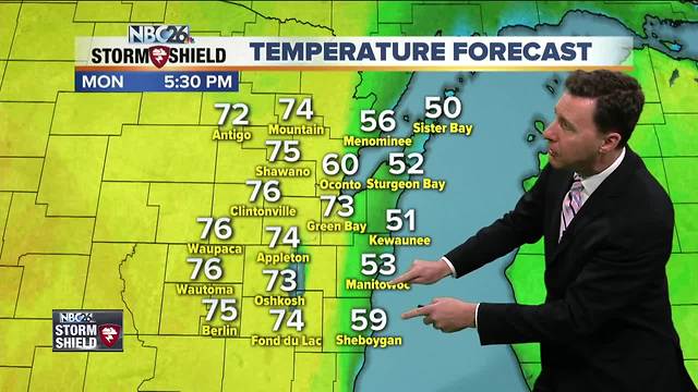
Get ready for a nice, warm but windy day.... unless you live along Lake Michigan. Sorry about that. Either way, we are going into the low-70s unless you're right next to Lake Michigan where it will be much cooler. Watch it with your burning because we're going to have an elevated fire danger today. Tonight will be a breezy and mild night with partly cloudy skies at times. Lows will be in the mid-50s. Tuesday will be another windy and warm day. Once again, if you live right next to Lake Michigan, it'll be cooler at times there. Get ready for some nice, warm highs in the upper-70s! It looks like our first, main threat at some showers and T'storms will be mainly later at night on Tuesday night, though the main threat of any stronger storms looks to be to our west. That could change just a bit as the system gets closer. Lows will be in the upper-50s. We're going to have to see where a stationary front sets up going into the middle part of the week to see exactly when some showers or T'storms could be rolling through again. Right now, it looks like there will be more chances of rain going through Wednesday and Thursday. Chances of rain may ramp up going into Thursday night. It'll still be pretty warm both days with highs in the mid-60s to around 70. The Wolf River near Shiocton, & New London remain under a flood warning for the time being with moderate flooding currently being observed. The river level at the observation site in Shiocton has climbed above the historical crest set back on April 1, 1922 of 14.1 feet to 14.13 feet. The river is expected to fall to fall to 13.8' by Tuesday morning.
-
 1:57
1:57
WGBA
1 year agoHow the City of Green Bay is hoping a $1.6M investment will make the community safer for pedestrians
4472 -
 2:46
2:46
WGBA
4 years agoMichael Fish's NBC 26 weather forecast
5 -
 2:30
2:30
WGBA
4 years agoMichael Fish's NBC 26 weather forecast
5 -
 2:20
2:20
WGBA
4 years agoMichael Fish's NBC 26 weather forecast
14 -
 2:21
2:21
WGBA
4 years agoMichael Fish's NBC 26 weather forecast
6 -
 2:25
2:25
WGBA
4 years agoMichael Fish's NBC 26 weather forecast
4 -
 1:55
1:55
WGBA
4 years agoMichael Fish's NBC 26 weather forecast
10 -
 2:11
2:11
WGBA
4 years agoMichael Fish's NBC 26 weather forecast
4 -
 1:50
1:50
WGBA
4 years agoMichael Fish's NBC 26 weather forecast
3 -
 1:45
1:45
WGBA
4 years agoMichael Fish's NBC 26 weather forecast
7