Michael Fish's NBC26 Storm Shield weather foreacst
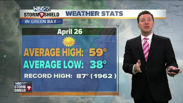
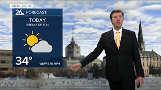
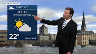
Today will be a pretty nice day with filtered sunshine at times. You may notice the breeze picking up as the day wears on, but otherwise, the daytime hours should be dry. Highs will top out in the mid-60s. Tonight, a cool front will be on the way, possibly bringing an isolated shower. It won't be a big deal with overnight lows in the mid-30s. A secondary area of low pressure will be on the way for your Friday. That's going to bring occasional showers into the area, mainly in the afternoon. Fridays highs will be cooler, struggling to even make it to 50. Any shower should eventually come to an end as we head through Friday evening, then the sky will clear out. It will be quite breezy out there with lows dropping into the low-30s. Saturday looks breezy in the morning, but the winds will slowly die down. At least we'll keep things dry with highs in the low-50s. Sunday also looks dry with less wind. Highs will make it to closer to normal levels in the upper-50s. If you are wanting some real warmth though, we are expecting 70s to return to the area early next week! This would be the first 70 degree day that we will see since October 21st when it reached 76 degrees. 3 rivers are under a flood warning, the Embarrass River near Embarrass & the Little Wolf River near Royalton. Minor flooding is expected. Many other rivers are approaching flood stage. The Wolf River is going to crest by this weekend or early next week. It has reached flood stage & as the floodwaters climb it will begin to surround homes and cover streets near the river in the Shiocton area, mainly homes along Island and Mill Streets. The Little Wolf River in Royalton affecting Waupaca County is expected to rise near flood stage by Thursday morning. Impacts include water that may surround some homes and structures in low lying area downstream between Royalton and west of New London. The Embarrass River near Embarrass is currently at flood stage.
-
 0:30
0:30
WGBA
1 year agoThree Degree Guarantee
369 -
 2:21
2:21
WGBA
4 years agoMichael Fish's NBC 26 weather forecast
6 -
 2:11
2:11
WGBA
4 years agoMichael Fish's NBC 26 weather forecast
4 -
 2:20
2:20
WGBA
4 years agoMichael Fish's NBC 26 weather forecast
14 -
 1:50
1:50
WGBA
4 years agoMichael Fish's NBC 26 weather forecast
3 -
 2:46
2:46
WGBA
4 years agoMichael Fish's NBC 26 weather forecast
5 -
 2:30
2:30
WGBA
4 years agoMichael Fish's NBC 26 weather forecast
5 -
 2:25
2:25
WGBA
4 years agoMichael Fish's NBC 26 weather forecast
4 -
 1:55
1:55
WGBA
4 years agoMichael Fish's NBC 26 weather forecast
10 -
 1:45
1:45
WGBA
4 years agoMichael Fish's NBC 26 weather forecast
7