Michael Fish's NBC26 Storm Shield weather forecast
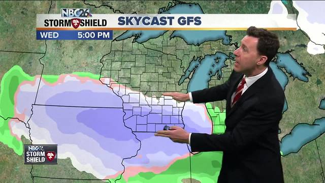
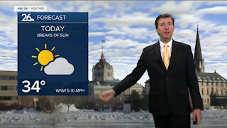
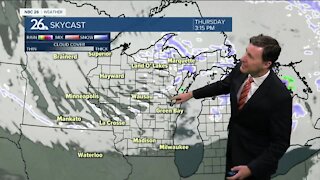
A compact, but strong area of low pressure will quickly track just south of the area this afternoon and evening. This will bring a quick round of snow/mix, especially the farther south you live. This will be nothing like we just saw, but will still bring accumulating snow to parts of the NBC26 viewing area.....mainly south of Green Bay. The best shot at the snow/mix will as we head through the afternoon into the evening. Highs will top out in the mid- to upper-30s. Some accumulations are likely farther south....right now it looks like a Dusting-2"/2-4"snowfall with the highest totals to the south of Appleton or Oshkosh. Since there is such a sharp cutoff on who could see snow, just a couple mile difference could make a difference in the snow forecast. It could wiggle a little before it gets here. North, you probably won't see a thing out of this. Anyone who would see accumulation out of this, this will most likely melt tomorrow. Later this evening this all should be done with lows in the upper-20s with the skies clearing out. Here comes the sun for Thursday with milder temperatures. Highs will be in the mid- to upper-40s. After that, things look quiet with moderating temps & melting snow into the weekend.
-
 1:45
1:45
WGBA
1 year agoStudents excited to start at "huge and beautiful" Vel Phillips Middle School
335 -
 2:20
2:20
WGBA
4 years agoMichael Fish's NBC 26 weather forecast
14 -
 2:21
2:21
WGBA
4 years agoMichael Fish's NBC 26 weather forecast
6 -
 1:55
1:55
WGBA
4 years agoMichael Fish's NBC 26 weather forecast
10 -
 2:11
2:11
WGBA
4 years agoMichael Fish's NBC 26 weather forecast
4 -
 1:50
1:50
WGBA
4 years agoMichael Fish's NBC 26 weather forecast
3 -
 1:45
1:45
WGBA
4 years agoMichael Fish's NBC 26 weather forecast
7 -
 3:03
3:03
WGBA
4 years agoMichael Fish's NBC 26 weather forecast
8 -
 2:33
2:33
WGBA
4 years agoMichael Fish's NBC 26 weather forecast
5 -
 2:30
2:30
WGBA
4 years agoMichael Fish's NBC 26 weather forecast
11