NBC26 Storm Shield Weather Forecast
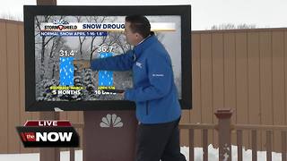
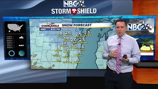
The worst is over. Green Bay has just experienced its 2nd largest snowstorm since records have been kept, though there have been spots with even more snow. The last time we saw a storm of this magnitude was over 130 years ago in 1888 when 29 inches of snow accumulated. Keep in mind, this is April. On the back side of this huge area of low pressure, we'll have a couple hit-and-miss snow showers, flurries or patchy freezing drizzle as the day wears on. Any additional accumulation will be minor. As you clean up, the winds will continue today out of the NW, but nothing as strong as we saw over the weekend. Highs will top out in the mid-30s with the fresh snowcover. Tonight, there may be a stray snow shower or flurry, but most of the night will just be breezy and quiet. Lows will bottom out in the mid-20s. Tuesday, we'll have a little more sun which will help melt a little bit of the snow, but it still will be much cooler than average. Highs will top out in the upper-30s. Tuesday night also looks quiet with lows in the mid-20s. Wednesday, there will be a chance of a wintry mix or just snow as we head through the day. Highs will top out in the 30s. Some accumulations are likely. Nothing compared to what we just saw. After that, things look quiet with a very slow moderation in temps into next weekend.
-
 4:35
4:35
WGBA
6 years agoNBC26 Storm Shield Weather Forecast
1 -
 2:34
2:34
WGBA
5 years agoNBC26 Storm Shield weather forecast
7 -
 2:16
2:16
Mohibbanchannels
4 months agoThundersnow Storm
251 -
 1:34
1:34
AmericanNewsBullet
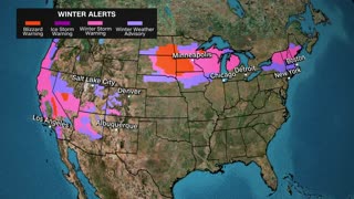
5 months agoBreaking News: Northeast USA Braces for Severe Winter Storm | Latest Updates
19 -
 3:44
3:44
WesleyCarnicle
1 year agoSouth Ark Weather is going live!
14 -
 0:45
0:45
JTN2020
1 year agoWeather updates on cross country winter storms ahead
77 -
 26:33
26:33
WeathermanPlus
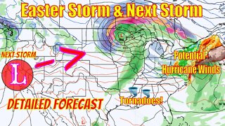
2 years agoEaster Snowstorm Detailed Forecast, Tornadoes, Major Snowfall & Potential Hurricane Winds!
23 -
 58:14
58:14
Great Lakes Weather
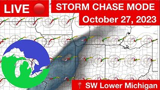
8 months agoLIVE STORM CHASE MODE Late Season in SW Lower Michigan -Great Lakes Weather
20 -
 0:08
0:08
DebfurmNM
3 years agoSnow Storm NM
66 -
 1:31
1:31
NTD
2 years agoMajor Winter Storm Batters Eastern US
164