NBC26 Storm Shield Weather Forecast
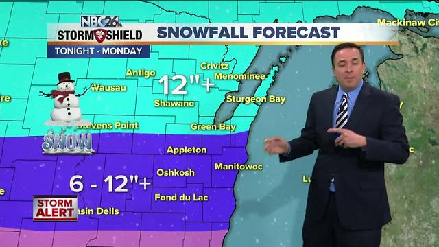
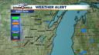
A complex and powerful storm system is going to affect us tonight through Monday. This precipitation continues into tonight with heavy snow, freezing rain & sleet. There could be 4-7" of snow accumulation in spots by the morning, especially from Green Bay north. Thundersnow is also possible. Saturday, there will still be a mix of freezing rain, sleet & snow, but you'll notice that this won't be as heavy of an event. Anything that will be falling will be melting a little on the pavement with the strong April sunshine, even behind the clouds. It will also very windy with NE wind gusts over 50 mph likely. Some Lakeshore flooding is possible along the bay. Highs will struggle to make it to freezing. Heavy snow returns Saturday night into Sunday. It'll also be windy, so blowing and drifting snow will be an issue. Another 7-10" will fall Saturday night into Monday morning. Totals after this second heavy round will be 6-12"+ south of Green Bay", 12-18"+ from Green Bay north. Light snow will taper to flurries on Monday. It'll still be windy with highs in the lower/mid 30s.
-
 1:57
1:57
WGBA
1 year agoHow the City of Green Bay is hoping a $1.6M investment will make the community safer for pedestrians
4452 -
 3:24
3:24
WGBA
5 years agoNBC26 Storm Shield Forecast
6 -
 3:24
3:24
WGBA
5 years agoNBC26 Storm Shield Forecast
8 -
 1:29
1:29
WGBA
5 years agoNBC26 Storm Shield Forecast
7 -
 4:01
4:01
WGBA
5 years agoNBC26 Storm Shield Forecast
15 -
 3:38
3:38
WGBA
5 years agoNBC26 Storm Shield Forecast
12 -
 3:17
3:17
WGBA
5 years agoNBC26 Storm Shield Forecast
11 -
 1:32
1:32
WGBA
5 years agoNBC26 Storm Shield Forecast
4 -
 3:35
3:35
WGBA
5 years agoNBC26 Storm Shield Forecast
7 -
 3:51
3:51
WGBA
5 years agoNBC26 Storm Shield Forecast
7