NBC26 Storm Shield weather forecast
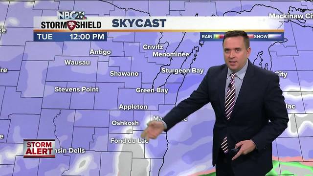
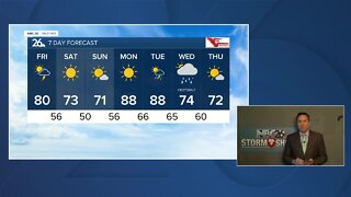
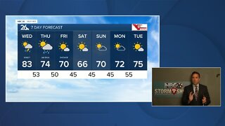
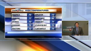
A WINTER STORM WARNING is in effect overnight tonight for most of Northeast Wisconsin and a WINTER WEATHER ADVISORY for our southern counties & Menominee County Michigan. Snow will gradually become widespread, mainly late tonight. The brunt of the whole event will be Tuesday morning through Tuesday night before tapering off late. Many of us should mostly likely see 6-10" by late Tuesday night with 3-6" amounts to the far south and north. It will be a heavy, wet snow so some melting & compressing is likely which may impact the final totals a bit. This will NOT blow and drift around much. Overnight lows will be in the upper-20s tonight with highs in the low 30s for Tuesday. The snow will be out of here by early Wednesday morning. Highs Wednesday will still be on the cold side with highs in the low-30s. There will be cold front heading through the area on Thursday afternoon or night. This could bring us another little bit of snow, but it doesn't look like a big deal. Highs Thursday will only be in the low/mid-30s. This cold weather continues right into the weekend. This will not be a very "spring-like" weather pattern for the next 7 days.
-
 0:30
0:30
WGBA
1 year agoThree Degree Guarantee
301 -
 3:24
3:24
WGBA
4 years agoNBC26 Storm Shield Forecast
6 -
 3:24
3:24
WGBA
4 years agoNBC26 Storm Shield Forecast
8 -
 1:29
1:29
WGBA
4 years agoNBC26 Storm Shield Forecast
7 -
 4:01
4:01
WGBA
4 years agoNBC26 Storm Shield Forecast
15 -
 3:38
3:38
WGBA
4 years agoNBC26 Storm Shield Forecast
12 -
 3:17
3:17
WGBA
4 years agoNBC26 Storm Shield Forecast
11 -
 1:32
1:32
WGBA
4 years agoNBC26 Storm Shield Forecast
4 -
 3:35
3:35
WGBA
4 years agoNBC26 Storm Shield Forecast
7 -
 3:51
3:51
WGBA
4 years agoNBC26 Storm Shield Forecast
7