Final Approach Hike to Chimney Rock! | Lower Crooked River | BLM | Prineville | Central Oregon | 4K
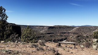
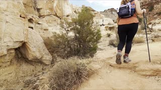
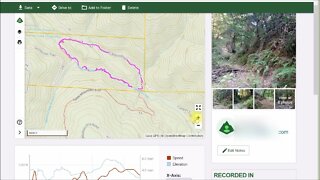
This was a Day Hike, starting at Chimney Rock Trailhead (across the road from Chimney Rock Campground), operated by the BLM (Bureau of Land Management), going 2.8 Miles Roundtrip, about 500 FT Elevation Gain, to the base of the world famous geological formation known as "Chimney Rock". The trail ascends a high desert wonderland canyon surrounded by juniper trees and sagebrush, with some great views looking down on Lower Crooked National Wild & Scenic River as you ascend. There are portions of the trail that are close to the edge of the canyon with a steep precipice - it never felt unsafe to me, but one must practice Situational Awareness and it may not be a good idea to bring kids up there unless they are well disciplined in safety protocols. Once you ascend the canyon you get up to a large plateau on the canyon edifice to explore for a while (a bench was particularly awesome) that yields direct views of the Mountains of Central Oregon - Three Sisters, Broken Top & Jefferson. It culminates with views of Chimney Rock, a lone geological formation standing high surrounded by high desert. I would recommend looking to the left of Chimney Rock down on a great canyon wide perspective of Lower Crooked National Wild & Scenic River snaking through the canyon.
Crooked River is divided into 3 National Wild & Scenic River Designated Sections - this one is the "Chimney Rock" Segment, named for this geological formation. Chimney Rock is also the name of the Trail, as well as the name of the Campground adjacent to the Trailhead.....clearly Chimney Rock has left its impression and mark on the nomenclature of this high desert wonderland river canyon area.
This is a very hot area, it is the high desert with direct sun almost the entire hike. I did this on 4/2/24, with a low of 35F and a high of 77F - I would not recommend doing this at the hottest time of day, particularly during Summer months of 80F - 100F, as the combination of steep elevation gain exertion and direct hot sun could be materialize into a dangerous hydration issue very very quickly.
-
 5:47
5:47
HikingViking
3 months agoThe Two EPIC Benches of Chimney Rock! | Lower Crooked River | BLM | Prineville | Central Oregon | 4K
50 -
 0:54
0:54
HikingViking
1 year agoReturning to Trailhead Beside Glistening Crooked River | Smith Rock State Park | Central Oregon | 4K
55 -
 6:16
6:16
4Crawler
1 year agoRock Outcrop Along the Stevens Canyon Trail
27 -
 1:14:24
Fire and Ice Outdoor Gear
2 years agoHiked from Roan Mountain from Cloud land to Ext 19 18.5 mile
144 -
 18:05
18:05
Cactus Hill
1 year agoUpper Muley Twist Canyon Trail in Capitol Reef National Park
12 -
 8:17
8:17
The 4Crawler Channel
1 year agoAbandoned Section of the Canyon Trail, near Gold Mine Creek
6 -
 2:54
2:54
Jerbeers
2 years agoChimney Rock hike
34 -
 8:30
8:30
4Crawler
2 years agoOld 1895 Stevens Canyon Road: Table Mountain crossing to Grizzly Flat crossing
6 -
 12:02
12:02
Random Adventures 2.0
2 years agoAppalachian Trail Pulpit Rock Overlook
10 -
 7:58
7:58
Life Among the Wildflowers
2 years agoTop of the Rock | Lost Canyon Cave & Nature Trail | Ridgedale, MO | Golf Cart Tour | Branson, MO
50