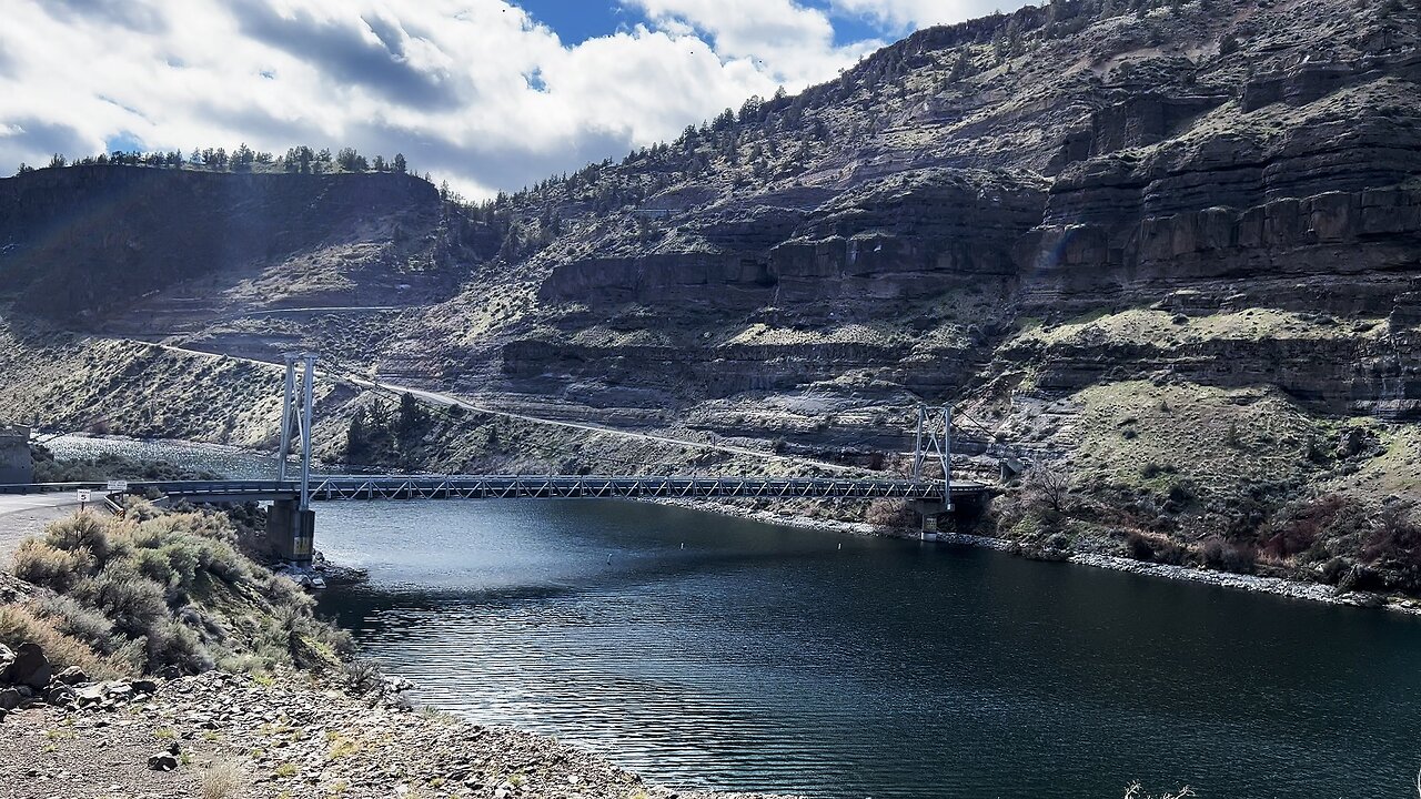
The Two EPIC Jordan Bridges Crossing Lake Billy Chinook @ The Cove Palisades State Park! | Oregon 4K
There are two Bridges in The Cove Palisades State Park area, one called the SE Jordan Bridge, the other the SW Jordan Bridge, going over the Crooked Arm and Deschutes Arm of Lake Billy Chinook. One is a two lane Bridge, the other a single lane Bridge, both very EPIC!
This area was explored on March 19, 2024. The weather was in the 30's in the AM up the the 50's by late afternoon. The road is very well paved throughout The Cove Palisades State Park and all the way through to Perry South Campground. If done prudently, it is not a difficult drive, high clearance and 4WD are NOT required in my humble opinion. Always check for weather!
The Cove Palisades State Park is easily a Top 3 State Park in the entire State of Oregon! Lake Billy Chinook's claim to fame is that its the confluence of 3 National Wild & Scenic Rivers - Crooked River, Deschutes River & Metolius River into a truly EPIC Lake-River-Canyon High Desert Wonderland! Thus this multi-tendrilled Lake is broken up into the Crooked River Arm, Deschutes River Arm & Metolius River Arm, each with its own very well developed infrastructure of Day Use Areas, Boat Ramp/Launches and very well groomed & manicured Shoreline Hiking Trails. Lake Billy Chinook is truly a World-Class Watersport Mecca of Boating, Fishing & Kayaking. This 4K Video Playlist captures the Highlights and Points of Interest of The Cove Palisades State Park and the Greater Lake Billy Chinook Area:
- Full Video from the official Park Entrance Sign stopping at every point of interest along the way up thru Monty Campground on the Metolius River!
- Crooked River Day Use Area
- Lower Deschutes River Day Use Area
- Upper Deschutes River Day Use Area
- Petroglyph of Crooked River & "The Island" National Natural Landmark
- Full Hike of Tam-a-lau Trail
- Both Jordan Bridges (THIS VIDEO!)
- Hoodoo Trailhead to Metolius Balancing Rocks
- Reviewing Each Campsite @ Perry South Campground and exploring the Boat Ramp/Launch and Shoreline Hiking Trail
- Reviewing Each Campsite @ Monty Campground
Due to some pre-scheduled hydroelectric dam work by PGE, the water levels were 2 FT - 5 FT lower than normal, with water levels expected to return back up to normal levels within weeks before peak season.
-
 16:30
16:30
HikingViking
27 days ago(4K UHD) REVIEWING EACH CAMPSITE @ East Shore Campground of Loon Lake! | BLM | Oregon Coast Range
63 -
 21:12
21:12
DeVory Darkins
1 day ago $4.31 earnedMigrants OPEN FIRE on Border Patrol Agent... Hunter Biden drops EXPLOSIVE interview
8.07K76 -
 57:40
57:40
Omar Elattar
9 months agoDean Graziosi: How I Made $70 Million & Retired My Mom At Age 24
9.48K -
 2:16:08
The Pascal Show
13 hours ago $1.52 earnedGHISLAINE BREAKS SILENCE! DOJ To MEET With Ghislaine Maxwell! Epstein List To Be Exposed & More News
10K1 -
 1:59:25
The Michelle Moore Show
1 day ago'Tulsi Gabbard on Obama Collusion, 2015 Prophecy Coming To Pass, Huckabee Slights Israel, Nathan Reynolds, & Pet Shots' Guest, Mark Taylor: The Michelle Moore Show (July 21, 2025)
34.2K84 -
 2:23:48
FreshandFit
7 hours agoShould Average Men Pay For Box?
60.5K20 -
 7:29:29
SpartakusLIVE
11 hours agoThe $1,000 Spartakus Gauntlet || Huskerrs and Twitty
113K1 -
 9:14:17
RalliedLIVE
11 hours ago $17.10 earnedHIGH OCTANE WARZONE SOLOS ALL DAY
105K5 -
 2:49:43
TimcastIRL
10 hours agoTrump Just ACCUSED Obama Of TREASON, Calls For CRIMINAL Charges | Timcast IRL
229K87 -
 10:19
10:19
MattMorseTV
15 hours ago $7.70 earnedTrump just went SCORCHED EARTH.
46.7K41