"Cap" on top of a cumulus cloud be a thunder-storm
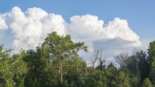
A three-minute video in real time shows a cumulus cloud with a "cap" on top. And this "cap" is also a cloud of vertical development, called pileus, which can be translated from Latin as a small light cap. "Pileus" is usually formed over cumulus and cumulonimbus clouds and is formed due to the rise of dry air at altitudes, which has a higher level of condensation, in contrast to the underlying humid air in the area of a cumulus or cumulonimbus cloud. Therefore, pileus looks like a "hood" or "cap" over a cumulus cloud, rapidly changing its shape. By the presence of pileus, it can be judged that in the clouds of convection, strong ascending air currents have formed, which can form cumulonimbus clouds. Thus, "pileus" can be considered indicators of an early thunderstorm.
-
 6:26
6:26
EdwardSchaffer
3 years agoSymphony #9, Clouds, Op 186 - I. Cumulus
31 -
 0:17
0:17
chapmansailingadventures
3 years ago $0.01 earnedCrazy storm cloud
1011 -
 3:19
3:19
Rwaycotte
3 years ago $0.05 earnedF/V Flying Cloud
58 -
 0:10
0:10
jojobeee
3 years agoAwesome funnel cloud
60 -
 0:12
0:12
RoastBeefTaco84
3 years agoCloud Management
25 -
 0:15
0:15
Amaranthine
3 years ago $0.57 earnedCloud waves
459 -
 0:29
0:29
akalonestar
3 years agoCessna 172 cloud surfing
1951 -
 1:07
1:07
Jon Stecker Photography
3 years agoCloud Time Lapse Compilation - 08-17-2019
152 -
 0:21
0:21
CaptanChemistry
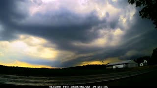
3 years agoShelf Cloud 6/22/2020
394 -
 1:55
1:55
VEXXHOST
3 years agoVEXXHOST Private Cloud
40