Michael Fish's NBC26 Storm Shield weather forecast
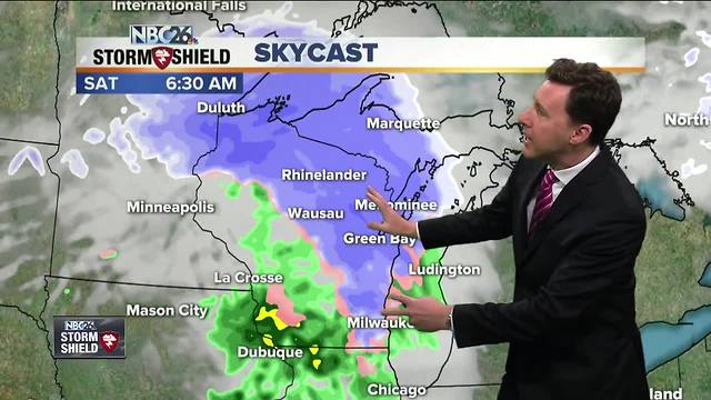
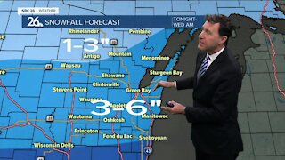
Today we'll see clouds on the increase and there will be a slight chance of rain/snow shower during the late afternoon, but that won't be the main system we're watching. Highs will top out in the mid-40s. The main system will bring a wintry mix to the area late tonight & Saturday morning. It should be cold enough to have everything start out as snow. Basically, the farther you live to the north, the more snow you're going to see out of this. From Green Bay south......a slushy Tr.-1"" is possible into Saturday morning with the highest totals north before this starts mixing with or changing to some rain. Parts of Northern Oconto & Marinette counties will see 3-5" by around the noon hour. Areas in between will see between 1-3" with the higher totals north. It's going to be a windy day with highs in the low-40s, but cooler readings to the north where there should be more snow. Saturday night will be cold and blustery with lows all the way down into the teens. Get ready for a breezy and cold Easter Sunday with highs only in the low-30s. At least it will be mostly sunny and dry. We have a unsettled and cold workweek coming up here starting on Monday afternoon. This will not be a nice start to April.
-
 1:45
1:45
WGBA
1 year agoFond du Lac Cardinals start the football season with a new $5.3 million nest
385 -
 2:11
2:11
WGBA
4 years agoMichael Fish's NBC 26 weather forecast
4 -
 1:50
1:50
WGBA
4 years agoMichael Fish's NBC 26 weather forecast
3 -
 1:54
1:54
WGBA
4 years agoMichael Fish's NBC 26 weather forecast
2 -
 1:39
1:39
WGBA
4 years agoMichael Fish's NBC 26 weather forecast
2 -
 2:27
2:27
WGBA
4 years agoMichael Fish's NBC 26 weather forecast
5 -
 2:32
2:32
WGBA
4 years agoMichael Fish's NBC 26 weather forecast
2 -
 2:22
2:22
WGBA
4 years agoMichael Fish's NBC 26 weather forecast
24 -
 2:19
2:19
WGBA
4 years agoMichael Fish's NBC 26 weather forecast
3 -
 2:34
2:34
WGBA
4 years agoMichael Fish's NBC 26 weather forecast
7