NBC26 Storm Shield weather forecast
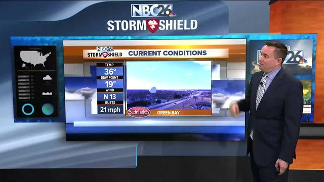
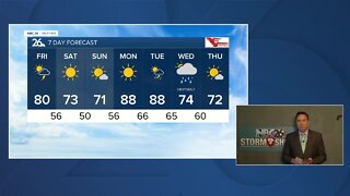
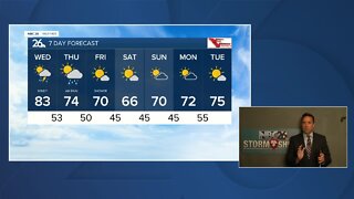
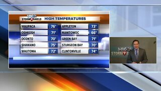
After seeing high temperatures in the mid and upper 40s yesterday, a cold that moved through during the overnight has put an end to the mild air. We are going to go back into the 30s today. At least we will have some sunshine but it will be colder with highs only in the mid and upper 30s. Winds will also be coming out of the northwest between 10 to 20 mph so wind chills will likely be in the upper 20s. Tonight with mostly clear skies to completely clear skies and calming winds out of the north and northwest, we will be dropping down into the teens but a few areas could get down into the single digits especially up towards the Northwoods. Friday will be a very similar like today with even more sunshine with high pressure moving over the Upper Midwest. Temperatures will be in the upper 30s with much lighter winds out of the north and northeast around 5 to 10 mph. The weekend looks great with Saint Patrick’s Day temperatures rising into the upper 40s or lower 50s under sunny skies. On Sunday.....highs will be in the around 50° with mostly sunny skies. Cooler mid 30s return for the beginning of next week’s work week. The overall temperature pattern looks to remain below average with also a below average chance in precipitation as well.
-
 1:45
1:45
WGBA
1 year agoFond du Lac Cardinals start the football season with a new $5.3 million nest
362 -
 3:24
3:24
WGBA
5 years agoNBC26 Storm Shield Forecast
6 -
 3:24
3:24
WGBA
5 years agoNBC26 Storm Shield Forecast
8 -
 1:29
1:29
WGBA
5 years agoNBC26 Storm Shield Forecast
7 -
 4:01
4:01
WGBA
5 years agoNBC26 Storm Shield Forecast
15 -
 3:38
3:38
WGBA
5 years agoNBC26 Storm Shield Forecast
12 -
 3:17
3:17
WGBA
5 years agoNBC26 Storm Shield Forecast
11 -
 1:32
1:32
WGBA
5 years agoNBC26 Storm Shield Forecast
4 -
 3:35
3:35
WGBA
5 years agoNBC26 Storm Shield Forecast
7 -
 3:51
3:51
WGBA
5 years agoNBC26 Storm Shield Forecast
7