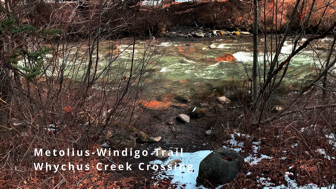
Approach to Whychus Creek Crossing (Ford) on Metolius-Windigo Trail! | HD | Deschutes Central Oregon
This was a Day-Hike in Central Oregon, Deschutes National Forest, Whychus Creek Trailhead, doing an approximately 10.5 Mile Super Loop (I ended doing about 14 Miles total with Side Trips) exploring and capturing all of the Highlights of the Whychus Creek Complex with shoreline sections, overlook sections as well as very interesting geological formations including overhangs, small cave areas and boulder fields! One motto for this area could be - come for the gorgeous Creek, stay for the interesting geology!
The elevation starts around 3400 FT and goes to around 4200 FT, with the natural machinations of the trail it is around 1200 FT elevation gain. There were snow and ice in patches along the trail so traction control devices are recommended for your feet in winter - I deployed Yaktrax Summit for the duration of the trip. The temperature was below freezing at 28F, wind chill 22F, and the ground was initially frozen, but the temperature skyrocketed into the 50's later in the day. The sky was blue bird initially but later turned to overcast. This was hiked on 3/11/2022, and there were of course NO Mosquitoes.
As far as road conditions, it's paved road all the way to the parking lot which is flat and has rocks in it, so it was a very easy and safe driving route. In my opinion, the road most definitely DOES NOT require 4-Wheel Drive, however do watch for road conditions, particularly snow/ice depending on the time of year, and do so at your own risk!
-
 5:49
5:49
HikingViking
2 months ago(4K UHD) REVIEWING EACH CAMPSITE @ Fifteen Mile Campground | Badger Creek Wilderness | Mount Hood NF
57 -
 2:23:48
FreshandFit
3 hours agoShould Average Men Pay For Box?
28.6K12 -

SpartakusLIVE
8 hours agoThe $1,000 Spartakus Gauntlet || Huskerrs and Twitty
96.7K1 -
 LIVE
LIVE
RalliedLIVE
8 hours ago $8.42 earnedHIGH OCTANE WARZONE SOLOS ALL DAY
2,147 watching -
 2:49:43
TimcastIRL
6 hours agoTrump Just ACCUSED Obama Of TREASON, Calls For CRIMINAL Charges | Timcast IRL
203K66 -
 10:19
10:19
MattMorseTV
11 hours ago $4.20 earnedTrump just went SCORCHED EARTH.
31.2K24 -
 2:37:18
Barry Cunningham
7 hours agoPRESIDENT TRUMP UNLEASHES HIS WRATH! NOW IT'S DEFINITELY GAME ON! HUGE TRADE WIN!
79.2K51 -
 1:27:56
Glenn Greenwald
9 hours agoSemafor Editor Ben Smith on Epstein Saga; How do MAGA Supporters Really Feel About Trump's Foreign Policy? Eddington Movie Review: Reflections on 2020 | SYSTEM UPDATE #490
144K69 -
 2:13:20
megimu32
6 hours agoOTS: Infomercial Insanity | 80s-00s Gadgets That Sold Big (and Made Us Buy)
35.8K7 -
 4:35:12
Amish Zaku
7 hours agoA Celebration of Ozzy Osbourne's Life, Music, and Spirit
25K7