Premium Only Content
This video is only available to Rumble Premium subscribers. Subscribe to
enjoy exclusive content and ad-free viewing.

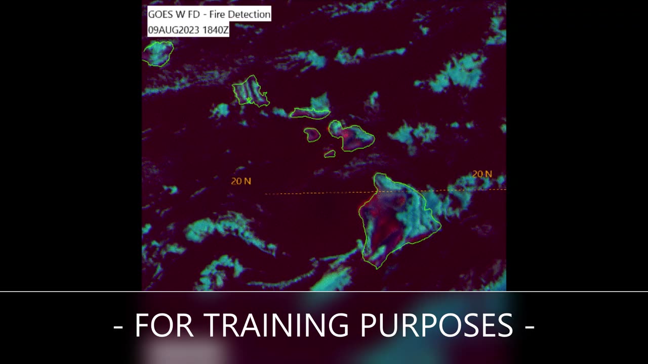
Satellite View During Maui Fires 2023 (Training Purposes Only)
10 months ago
101
This clip features a satellite imagery loop obtained from the GOES-West meteorological satellite and U.S. Air Force Mark IV-B satellite viewing software with a false-color multispectral enhancement named "Fire Detection" applied, which is designed to highlight fires with a bright yellow or orange color. Note the imagery contains daytime and nighttime images, where the colors appear to drastically shift as the terminator (delineation between day and night) passes over. Land that naturally heats up from sunlight during the day will appear a reddish-pink until it cools down at night. This is for training purposes only.
Loading comments...
-
 LIVE
LIVE
BrookieMonster
1 hour ago $0.01 earnedChristmas Stream: Marvel Rivals with CallmeSeags 🎄
783 watching -
 LIVE
LIVE
TheSaf3Hav3n
3 days ago| RUMBLES FIRST SUBATHON IS HERE!!! | DAY 4 |
1,362 watching -
 LIVE
LIVE
Joe Donuts Gaming
3 hours ago🟢 Live : Christmas is Here!! | Fortnite, Caroling, Light Tours and Donos !!
696 watching -
 LIVE
LIVE
CLUJ
2 hours agoCHRISTMAS EVENING HYPE!! LETS HAVE FUN GAMING!!
493 watching -
![I AM FINALLY BACK :: PUBG: BATTLEGROUNDS :: RUMBLE NOW HAS GIFTED SUBS!!! [Merry Christmas] {18+}](https://1a-1791.com/video/fwe1/22/s8/1/e/f/C/6/efC6v.0kob-small-I-AM-FINALLY-BACK-PUBG-BATT.jpg) LIVE
LIVE
a12cat34dog
4 hours agoI AM FINALLY BACK :: PUBG: BATTLEGROUNDS :: RUMBLE NOW HAS GIFTED SUBS!!! [Merry Christmas] {18+}
227 watching -
 3:55:42
STARM1X16
4 hours agoMerry Christmas Fortnite
9.95K1 -
 2:45:33
Sgtfinesse
4 hours agoMerry Christmas Night
21.6K5 -
 LIVE
LIVE
tacetmort3m
20 hours ago🔴 LIVE - (MERRY CHRISTMAS) TIME TO SPREAD DEMOCRACY - HELLDIVERS 2 OMENS OF TYRANNY
55 watching -
 12:42
12:42
Cooking with Gruel
18 hours agoBrown Butter Trifle with Salted Caramel and Cinnamon Apple
5.49K2 -
 2:46
2:46
BIG NEM
7 hours agoDiscovering RAKIJA: The Holy Liquer of the Balkans
4.03K2