Satellite View During Maui Fires 2023 (Training Purposes Only)
1 year ago
112
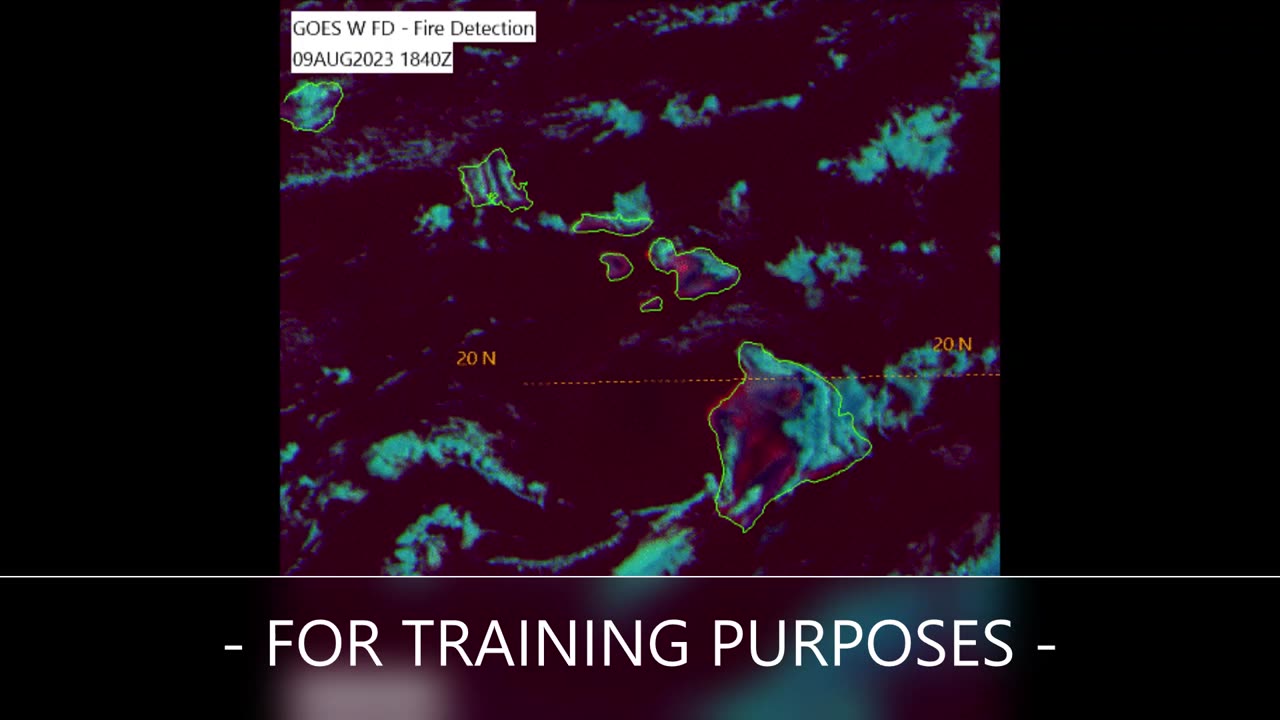
This clip features a satellite imagery loop obtained from the GOES-West meteorological satellite and U.S. Air Force Mark IV-B satellite viewing software with a false-color multispectral enhancement named "Fire Detection" applied, which is designed to highlight fires with a bright yellow or orange color. Note the imagery contains daytime and nighttime images, where the colors appear to drastically shift as the terminator (delineation between day and night) passes over. Land that naturally heats up from sunlight during the day will appear a reddish-pink until it cools down at night. This is for training purposes only.
Loading comments...
-
 LIVE
LIVE
Game On!
14 hours agoKyle Shanahan In THE HOT SEAT To Get The 49ers Back To The Super Bowl!
2,024 watching -
 15:59
15:59
Degenerate Jay
21 hours ago $1.67 earnedThe Rejected Spider-Man: No Way Home Scene That Changed The Whole Movie
8.86K2 -
 10:13
10:13
ARFCOM Reviews
14 hours ago $0.91 earnedIntegrally Suppress Your PCC with Novox X-SD
2.17K1 -
 5:19
5:19
Rena Malik, M.D.
22 hours ago $2.13 earnedDoctor explains Who has a More Active Sex Drive - Men vs. Women?
8.16K11 -
 1:56:44
MG Show
19 hours agoEpstein, Comey, Brennan: It’s ALL Connected; Pandora’s Box Premium
20K23 -
 3:43:36
megimu32
11 hours agoOFF THE SUBJECT: FAFO Friday w/ Pepkilla
75.3K13 -
 2:16:11
I_Came_With_Fire_Podcast
15 hours agoCCP INFLUENCE IN U.S. | DOXXING ICE AGENTS | PAY YOUR OWN LOAN
36.9K15 -
 15:30
15:30
BlackBeltBarrister
16 hours ago $10.98 earnedThey will screw us all with this!!
59.1K25 -
 2:04:22
TimcastIRL
11 hours agoDan Bongino AND Kash Patel THREATEN TO QUIT FBI Over Botched Epstein Release | Timcast IRL
296K271 -
 5:10:31
Turning Point USA
15 hours agoSAS IS LIVE! Pete Hegseth, Don Jr., Tucker Carlson, Charlie Kirk and more... in Tampa, FL!
851K98