Ocean Depths Unveiled: Landsat & the Calypso Caper
1 year ago
28
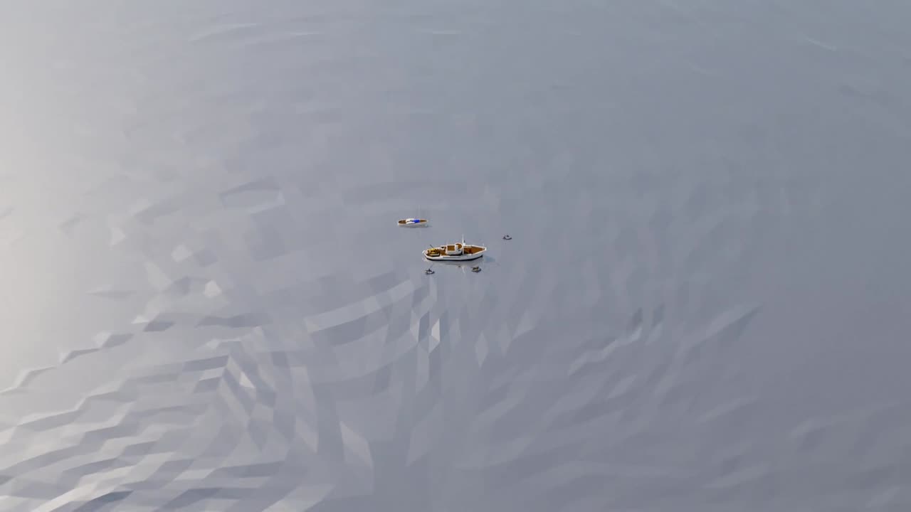
Dive into the captivating tale of Landsat and the Calypso Caper, a summer expedition in 1975 led by Jacques Cousteau and NASA to explore the capabilities of Landsat in measuring ocean depths. 🚢📡 Uncover the story through preserved photography and documents shared by David Lychenheim, the expedition's communications engineer. Witness how this groundbreaking experiment paved the way for satellite-derived bathymetry, revolutionizing chart revisions and enhancing navigation safety for ships worldwide. 🌐⚓ Explore the synergy of science and exploration as Landsat continues its mission to capture Earth's ever-changing landscapes. 🌊🌏 #LandsatDiscovery #SatelliteBathymetry #OceanExploration
Loading comments...
-
 1:34:32
MattMorseTV
1 day ago $20.05 earned🔴Trump's MASSIVE UPDATE.🔴
18.1K89 -
 21:06
21:06
Nikko Ortiz
12 hours agoBodycam's Zombie Update Is Crazy...
2.01K1 -
 17:11
17:11
MetatronHistory
1 day agoMedieval Christianity in the Historical Context of Power
1.41K3 -
 2:16:21
Side Scrollers Podcast
17 hours agoTwitch has a SERIOUS Problem + Leaflit’s VIRAL Interview + More | Side Scrollers
38.9K13 -
 21:55
21:55
GritsGG
13 hours agoMega Win Streak On Warzone! Over 4100 Wins on BO6 WZ!
758 -
 20:22
20:22
The Pascal Show
1 day ago $2.61 earnedARE THEY IGNORING HER?! Is The White House & FBI Ignoring Candace Owens' A**assination Claims?!
25.1K15 -
 1:00:45
TruthStream with Joe and Scott
1 day agoMondays with Matt Geiger from Verity Metals: Gold, Silver, The Housing Market and more. Live 12/1 6pm pacific #519
4.11K -
 2:17:46
The Connect: With Johnny Mitchell
3 days ago $14.70 earnedA Sitdown With The Real Walter White: How An Honest Citizen Became A Synthetic Drug Kingpin
76.9K1 -
 2:40:08
PandaSub2000
9 hours agoDEATH BET | Solo Episode 01 (Edited Replay)
1.65K -
 LIVE
LIVE
Lofi Girl
3 years agolofi hip hop radio 📚 - beats to relax/study to
780 watching