Michael Fish's NBC26 Storm Shield weather forecast
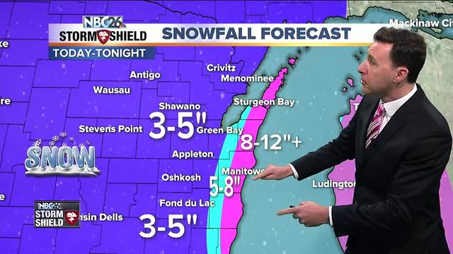
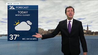
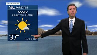
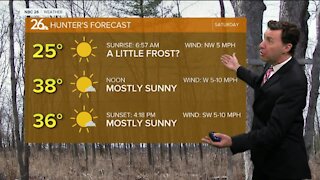
Winter Storm Warnings and Winter Weather Advisories are in effect for Northeast Wisconsin. Sheboygan, Manitowoc, Kewaunee, and Door County are under a Winter Storm Warning. A winter weather advisory is in effect for the rest of Northeast Wisconsin. We are underway with a odd weather setup with a clipper system bringing winds off of Lake Michigan. There is a heavy band of lake enhanced snow rotating its way counter clockwise. You will know when this particular band rolls through as the snow will become heavy at times. This is lake effect, so there is always some uncertainty who sees how much exactly where near Lake Michigan. Either way, daytime totals for those away from Lake Michigan will be a general 2-4". There will be a sharp increase in daytime totals as you head closer to the lake with daytime totals of 5-8" there. Luckily the winds won't be too bad, except a little higher near the lake. As we head through the night, snow bands coming off the lake will begin to drift south as winds start to shift straight out of the north. By 5 am, the lake effect snow bands should move offshore of Northeast Wisconsin. Another Tr-1" is possible inland, but near the lake, that lake effect band will still be rotating southward. There will be a large variation with distance closer to the lake with totals there anywhere from 5-12" or even more in isolated locations. The lower totals will be the farther you head inland. The rest of the area should most likely end up with 3-5" inches of snow. Overnight lows will be in the low-teens. Any lake effect snow shower will end early tomorrow, otherwise expect mostly cloudy skies with a few flurries possible. Highs will top out in the mid-20s. We'll clear out the skies tomorrow night with lows in the low-single digits. Wednesday looks breezy, but dry with highs inl the low-20s.
-
 1:45
1:45
WGBA
1 year agoStudents excited to start at "huge and beautiful" Vel Phillips Middle School
375 -
 2:35
2:35
WGBA
4 years agoMichael Fish's NBC 26 weather forecast
2 -
 2:05
2:05
WGBA
4 years agoMichael Fish's NBC 26 weather forecast
4 -
 2:00
2:00
WGBA
4 years agoMichael Fish's NBC 26 weather forecast
5 -
 2:46
2:46
WGBA
4 years agoMichael Fish's NBC 26 weather forecast
1 -
 2:23
2:23
WGBA
4 years agoMichael Fish's NBC 26 weather forecast
1 -
 2:08
2:08
WGBA
4 years agoMichael Fish's NBC 26 weather forecast
3 -
 1:49
1:49
WGBA
4 years agoMichael Fish's NBC 26 weather forecast
1 -
 2:15
2:15
WGBA
4 years agoMichael Fish's NBC 26 weather forecast
4 -
 2:28
2:28
WGBA
4 years agoMichael Fish's NBC 26 weather forecast
2