Unveiling Earth's Canvas: Landsat 9 Data Now Accessible!
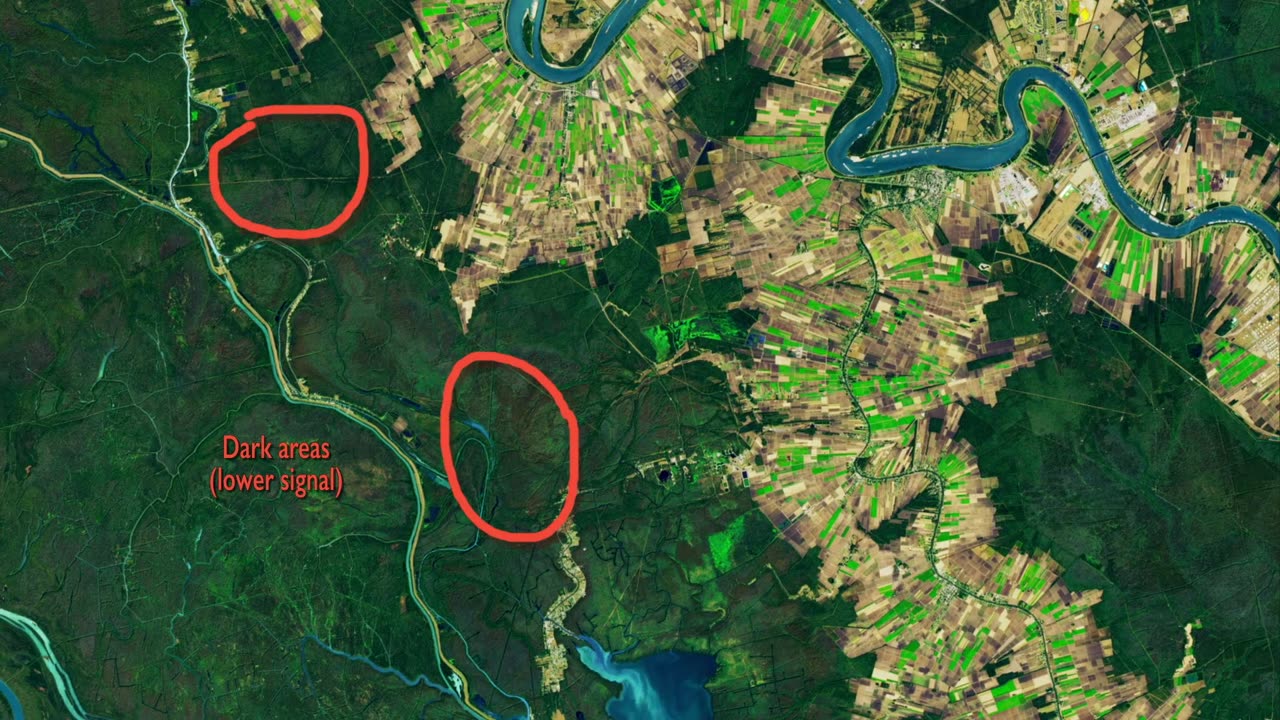
Dive into the wealth of knowledge about our planet with the availability of Landsat 9 data for download! Launched on Sept. 27, 2021, Landsat 9, alongside its predecessor Landsat 8, promises a treasure trove of high-quality, medium-resolution images of Earth's landscapes and coastal regions every eight days.
Join the Landsat mission team on their journey of testing and calibrating the new satellite and its instruments. Witness commissioning activities, including a unique flyby under its sister satellite, Landsat 8, confirming precise data alignment. Calibration techniques, such as tilting the spacecraft to capture the full Moon, ensure the instruments consistently detect light.
Managed jointly by NASA and the U.S. Geological Survey (USGS), the Landsat Program has been a stalwart observer of Earth since 1972, continually enhancing our understanding of the planet's dynamic changes. Explore, download, and contribute to the ever-growing legacy of Earth observation with Landsat 9! #Landsat9Launch #EarthObservation #LandsatLegacy #Landsat9Data
-
 2:49:38
megimu32
3 hours agoOFF THE SUBJECT: Chill Stream, Music & Fortnite Chaos 🎹🎮
14.6K3 -
 2:24:09
vivafrei
13 hours agoEp. 290: Canada's Darkest Week; Comey Fix is In! Tariffs, SNAP, Hush Money Win & MORE!
206K151 -
 LIVE
LIVE
EricJohnPizzaArtist
5 days agoAwesome Sauce PIZZA ART LIVE Ep. #68: DDayCobra Jeremy Prime!
205 watching -
 LIVE
LIVE
meleegames
3 hours ago32X Roulette - 30 Years. 32 Games. 32X.
92 watching -
 LIVE
LIVE
SOLTEKGG
1 hour ago(30+ KILL WORLD RECORD) - Battlefield 6
49 watching -
 1:18:00
HELMETFIRE
2 hours ago🟢GAMING WITH FIRE EP15🟢
2.88K -
 LIVE
LIVE
BubbaSZN
3 hours ago🔴 LIVE - FARTNITE W/ @CATDOG & @CHEAP
32 watching -
 2:54:01
LadyDesireeMusic
6 hours ago $0.17 earnedCookin & Convo - Potato Soup, Ham & Apple Pie
38.5K5 -
 27:05
27:05
Robbi On The Record
9 hours ago $0.04 earnedThe Secret to Aging Strong: What Your Body’s Been Trying to Tell You
23.8K4 -
 3:27:19
bucketofish
7 hours ago///ARC Raiders || Loot, Scoot + Boogie
27.8K