Michael Fish's NBC26 weather forecast
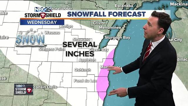
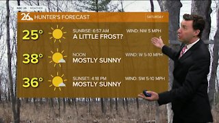
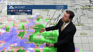
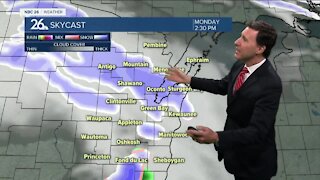
Get ready for a very "winter-like" day in the temperature and wind department, today. It's going to be cold and blustery with highs only in the upper-teens. High temperatures for your Tuesday will only make it into the middle- to upper-teens with wind chills well down into the single digits. Most of tonight looks quiet until we hit the early morning hours overnight when we'll have our first chances of snow. We have a system on the way for mainly the daytime hours on Wednesday. Now, we have a very long way to go with this system, but this one looks to strengthen as it approaches. The computer models are still bouncing all over the board. To pin down an exact snowfall with this at this point is tough, but if the current track holds, expect several inches of snow, with possibly some enhancement by Lake Michigan which would bump up the totals south of Door County. Winds will be slowly picking up through the day with highs in the mid-20s. Any snow shower would taper off as we head through Tuesday night with minimal, additional accumulation. It'll be breezy with lows in the low-teens. Thursday should be relatively quiet, though we could see a couple of flurries with highs in the low-20s. Friday or Saturday, we could have another clipper system on the way, but it's too early to tell what's going to happen with that one. Temperatures warm up just a little into the weekend.
-
 3:36
3:36
WGBA
2 years agoWill it be necessary to have both the AC & the heat on during the same day??
3971 -
 2:28
2:28
WGBA
4 years agoMichael Fish's NBC 26 weather forecast
2 -
 2:10
2:10
WGBA
4 years agoMichael Fish's NBC 26 weather forecast
3 -
 1:48
1:48
WGBA
4 years agoMichael Fish's NBC 26 weather forecast
4 -
 2:32
2:32
WGBA
4 years agoMichael Fish's NBC 26 weather forecast
2 -
 2:47
2:47
WGBA
4 years agoMichael Fish's NBC 26 weather forecast
5 -
 2:08
2:08
WGBA
4 years agoMichael Fish's NBC 26 weather forecast
7 -
 2:42
2:42
WGBA
4 years agoMichael Fish's NBC 26 weather forecast
3 -
 2:40
2:40
WGBA
4 years agoMichael Fish's NBC 26 weather forecast
4 -
 2:33
2:33
WGBA
4 years agoMichael Fish's NBC 26 weather forecast
2