Burr Trail Switchbacks in Capitol Reef National Park
Burr Trail Switchbacks
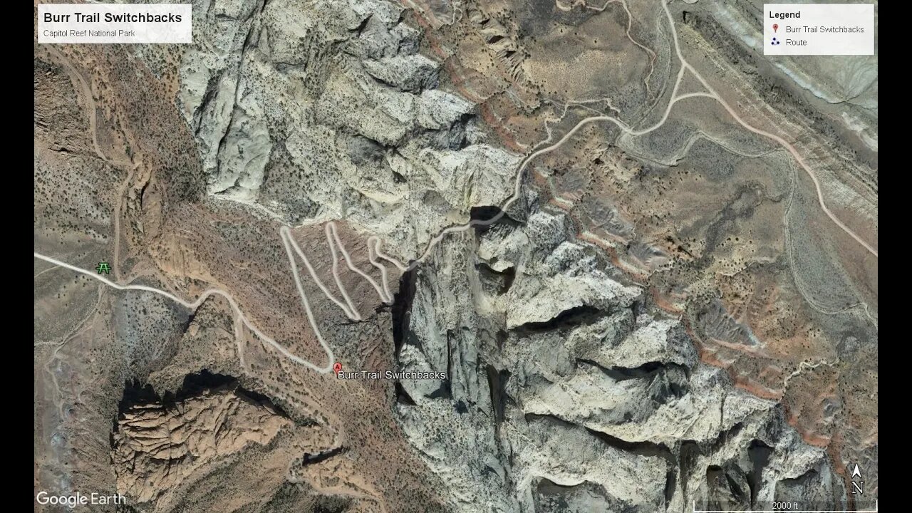
The Burr Trail Switchbacks is in Garfield County Utah and are one of the few passages across the Grand Staircase, a geological formation which greatly vexed early stagecoach travelers crossing the plains.
At this tectonic boundary (known as a monocline or more commonly known as the “Waterpocket Fold) the western plate juts sharply above the eastern plate, presenting a largely unbroken wall-like barrier nearly 100 miles long. This generally insurmountable wall of rock is positioned within Glen Canyon National Recreation Area, Capitol Reef National Park, and Grand Staircase-Escalante National Monument (Which encompasses the largest land area of all U.S. National Monuments, slightly larger in area than the State of Delaware).
The switchbacks and the road were named after John Atlantic Burr (He was born in 1846 while crossing the Atlantic thus his middle name Atlantic) and lived with his family in Salt Lake City before moving south to establish the town of Burrville, Utah in 1876. He established the Burr Trail across extremely rugged territory, including Waterpocket Fold, Burr Canyon, and Muley Twist Canyon as a way of moving cattle between lower winter grazing ranges on the east side of Waterpocket Fold and higher summer grazing ranges on the west.
The section of the Burr Trail within Capitol Reef National Park is still unpaved and is in a scenic but isolated section of an already remote National Park that can be reached via Utah Scenic Highway 12 or from the Notom-Bullfrog Road.
(Source https://www.atlasobscura.com/places/burr-trail-switchbacks)
Please note: Although in dry weather the Burr Trail is easily accessible to passenger cars, wet weather may make the road impassable even for 4-wheel drive vehicles. Check with rangers or local officials for weather and road conditions. Recreational Vehicles and trailers are not recommended.
Originally, only the switchbacks were named the Burr Trail, a route used by cattleman in the late 19th century to move cattle back and forth between winter and summer ranges.
Today, the entire road from Bullfrog to Boulder is known as the Burr Trail.
To access a 16-page PDF produced by the National Park Service follow this link:
https://www.nps.gov/glca/planyourvisit/upload/BurrTrailDrivingGuide2019_508.pd
The Burr Trail and the Switchbacks in the Capitol Reef National Park do
offer some of the most eye-popping scenery of any drive in Southern Utah, the 67-mile Burr Trail twists and turns from the town of Boulder all the way to tiny Bullfrog, which lies at the tip of one of the many fingers of Lake Powell, within Glen Canyon National Recreation Area. Only an 8½-mile stretch of Burr Trail passes through Capitol Reef National Park, but it's arguably the most spectacular section. It's especially dramatic if approaching from the west from Boulder through Grand Staircase–Escalante National Monument. When you reach the Capitol Reef National Park border, the road becomes unpaved but is still generally (unless there's been heavy rain or snow) passable with a passenger car. It curves through juniper-dotted, red-rock countryside, offering sweeping views of the Strike Valley, the Studhorse Peaks, and—in the distance—the Henry Mountains. After about 3 miles, you'll crest the upper, western ridge of the Waterpocket Fold, a 100-mile-long monocline in the earth's crust, and then zigzag some 800 feet down a series of dramatic switchbacks to the lower end of the fold. From here, Burr Trail Road continues southeast past the junction with Notom-Bullfrog Road (where a left turn leads back up to Torrey) toward the small village of Bullfrog.
-
 2:32:23
The Quartering
5 hours agoOn To The Big Bosses! Act 2 Of Expedition 33
44.9K4 -
 LIVE
LIVE
SpartakusLIVE
7 hours agoTiger Blood RESTOCKED and 30% off w/ code SPARTAKUS30
489 watching -
 24:58
24:58
Law&Crime
8 hours ago $1.60 earnedSecond Note Leaves Disturbing Clues in New York City Killings
28.3K9 -
 1:36:57
Badlands Media
23 hours agoAltered State S3 Ep. 39: Earthquakes, Energy Games & the Fall of the Narrative
62.8K13 -
 2:04:07
Due Dissidence
13 hours agoCharlie Kirk's GAZA LIES, Caitlin Clark Stalker, Palantir Goes Hollywood - w/ Kyle Matovcik | TMWS
27K8 -
 2:54:43
I_Came_With_Fire_Podcast
14 hours agoAmerica First, Trump Threatens China, Your Friendly Neighborhood Illegal, EPA Gets a "W"
29.1K6 -
 LIVE
LIVE
Geeks + Gamers
4 hours agoGeeks+Gamers Play- MARIO KART WORLD
146 watching -
 8:28:19
Dr Disrespect
13 hours ago🔴LIVE - DR DISRESPECT - BATTLEFIELD 1 - FULL GAME
168K7 -
 1:39:26
Glenn Greenwald
9 hours agoStephen Miller's False Denials About Trump's Campus "Hate Speech" Codes; Sohrab Ahmari on the MAGA Splits Over Antitrust, Foreign Wars, and More | SYSTEM UPDATE #495
112K69 -
 1:57:28
Omar Elattar
9 hours agoThe $300M CEO: "The One Skill That Made Me Rich In 15 Different Countries!"
18.9K