Premium Only Content

NASA Releases Incredible Visual Simulating 2017's Hurricanes
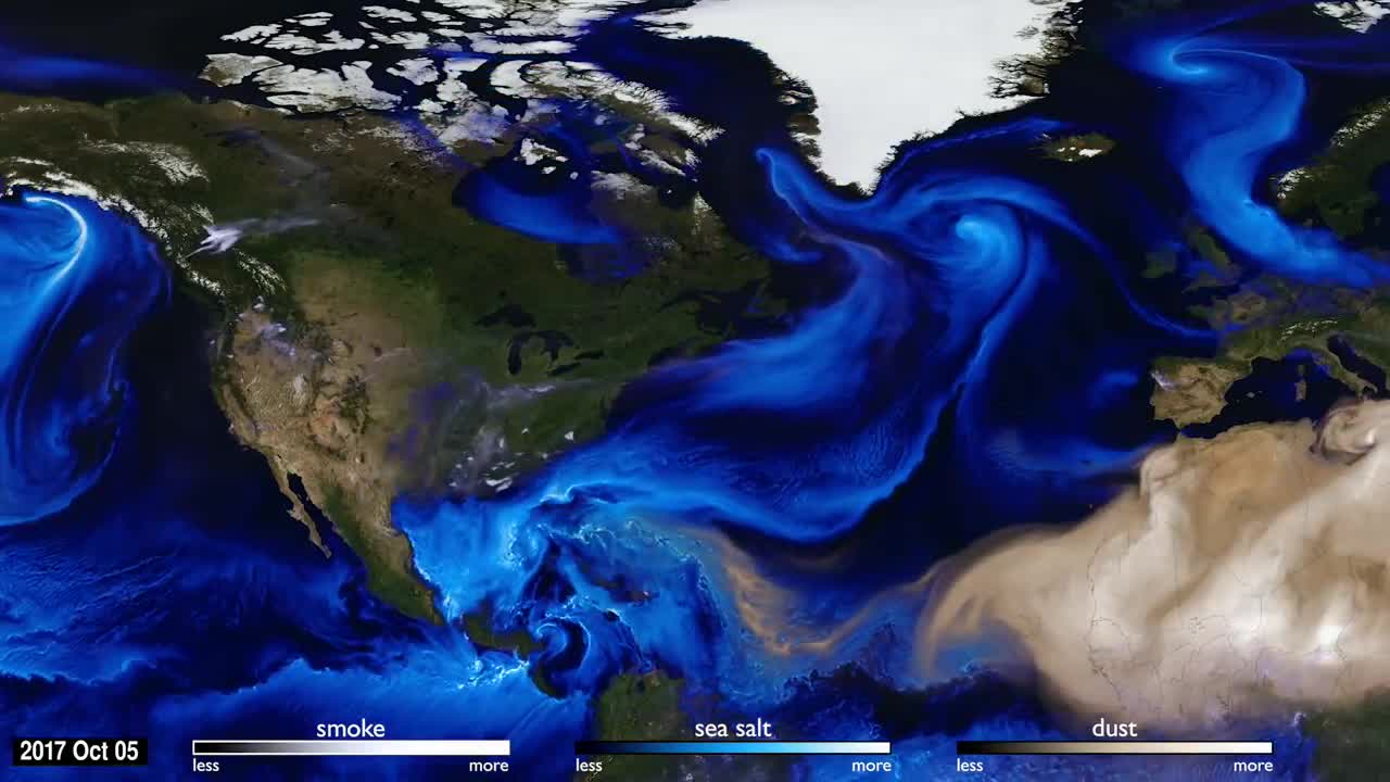
You can see the atmosphere by tracking what the wind carries. Tiny particles known as aerosols are carried by the air around the globe, such as smoke, dust, and sea salt which are transported by the air across the globe, making visible weather patterns and other normally invisible physical processes.
This visualization uses data from NASA satellites, combined with mathematical models in a computer simulation allow scientists to study the physical processes in our atmosphere. By following the sea salt that is evaporated from the ocean, you can see the storms of the 2017 hurricane season.
One of the most noticeable things about the simulation is how far the particles can travel.
For example, smoke from fires in the Pacific Northwest gets caught in a weather pattern and pulled all the way across the US and over to Europe. The visualization also shows dust from the Sahara blow into the Gulf of Mexico. To understand the impacts of aerosols, scientists need to study the process as a global system.
During the hurricane season in 2017, tropical storms and hurricanes were visible in the visualization because of the sea salt that is captured by the storms. Strong winds at the surface lift the sea salt into the atmosphere and the particles are incorporated into the storm.
Computer simulations using NASA's Goddard Earth Observing System (GEOS), a family of mathematical models, allow researchers to see how different processes fit together and evolve as a system. Combined with data from NASA's Earth observing satellites, the supercomputer simulations enhance scientific understanding of specific chemical, physical and biological processes.
Credit to 'NASA Goddard'.
-
 3:09
3:09
rumblestaff
5 years agoNASA releases highest resolution image of Mars and it's incredible
7.06K3 -
 2:44
2:44
rumblestaff
4 years agoNASA's Incredible New Transformer Rover Can Explore the Toughest Terrain
3051 -
 0:43
0:43
Just the News
5 years agoNASA launches historic Mars rover Perseverance
8.56K2 -
 5:07
5:07
rumblestaff
4 years agoStunning Flyover of Jupiter Created From NASA Juno Imagery
1.52K4 -
 1:53
1:53
Newsy
5 years agoNASA Renaming D.C. Headquarters After Mary W. Jackson
5.58K3 -
 0:42
0:42
KTNV
4 years agoNASA releases first-ever agency-wide economic impact report
54 -
 0:32
0:32
rumblestaff
4 years agoNASA footage shows spacecraft's incredible tough-and-go on asteroid
3.2K -
 1:23
1:23
WKBW
5 years agoBuffalo Games releases board game with NASA
31 -
 1:33
1:33
NurseBrenton
4 years ago $0.99 earnedSeeing this NASA SpaceX launch is nothing short of extraordinary
3.2K3 -
 5:41
5:41
Itchigos Visual Pinball Channel
4 years ago $0.05 earnedVisual Pinball build
3282