Michael Fish's NBC26 weather forecast
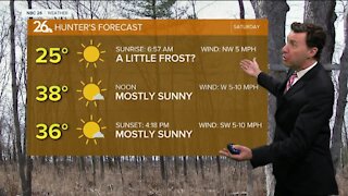
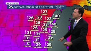
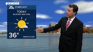
After a record-breaking cold morning in Green Bay, a cold breeze is turn off of Lake Michigan for awhile, we could see some lake effect snow showers right along Lake Michigan. Lake effect snow is tricky, but if you end up under one of these snow showers by the lake, you could see some snow accumulation. At least we'll have a little less wind. Highs will only be in the upper-20s today. Late tonight as a system approaches, we could see some light snow develop, but as of now, it looks like most of that should be mainly to the north, and though there may be some accumulation, it should be only Tr.-1". Lows will be in the upper-20s, before rising overnight. Saturday, some folks could see some snow, while others may start mixing in rain. Either way, some accumulation is possible, and the way it looks at the moment, it could be either side of 1". With the potential of rain mixing in, this forecast could change a bit as we get closer to the event. Highs will be in the mid-30s. Saturday night on the backside of the departing system, we could see a little light snow/rain or possibly freezing drizzle. Any accumulation would be minor, if anything. As of right now, most of Sunday looks dry, but there's a slight chance of folks farther south to see a rain or snow shower with highs around 40.
-
 0:30
0:30
WGBA
1 year agoThree Degree Guarantee
369 -
 2:28
2:28
WGBA
4 years agoMichael Fish's NBC 26 weather forecast
2 -
 2:32
2:32
WGBA
4 years agoMichael Fish's NBC 26 weather forecast
2 -
 2:47
2:47
WGBA
4 years agoMichael Fish's NBC 26 weather forecast
5 -
 2:08
2:08
WGBA
4 years agoMichael Fish's NBC 26 weather forecast
7 -
 2:42
2:42
WGBA
4 years agoMichael Fish's NBC 26 weather forecast
3 -
 2:40
2:40
WGBA
4 years agoMichael Fish's NBC 26 weather forecast
4 -
 2:33
2:33
WGBA
4 years agoMichael Fish's NBC 26 weather forecast
2 -
 2:42
2:42
WGBA
4 years agoMichael Fish's NBC 26 weather forecast
4 -
 2:13
2:13
WGBA
4 years agoMichael Fish's NBC 26 weather forecast
3