Export DWG 3D to Google Earth in "Topography in AutoCAD or BricsCAD" software
7 months ago
13
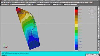
"Topography in AutoCAD or BricsCAD" software can draw a 3D DWG file in Google Earth, by generating a 3D KML file type. The program is an add on for AutoCAD or Bricscad.
In the example is a bridge designed with the BRIDGE program.
https://rcad.eu/triangulation-autocad/
https://rcad.eu/bridge/
Loading comments...
-
 5:26
5:26
AutoCAD and BricsCAD add ons for surveyors and engineers
7 months agoTopography in AutoCAD, triangulation, isolines, volume, sections
321 -
 0:52
0:52
eqsshan
2 years agoAutoCAD Creation #1
1.24K -
 1:19:40
TD Vision U
2 months agoPalladian Style // Complete Tutorial // AutoCAD Architecture 2025
119 -
 37:53
37:53
TheRedBrickArchitecture
1 year agoAutoCAD Tutorial For Beginners
78 -
 17:51
17:51
Verwey Drafting Inc.
1 month agoAutoCAD 2025 - 15 Minute Tutorial For BEGINNERS!
6 -
 7:00
7:00
AllVisuals4U | Design & Engineering
5 months ago👨🎓 FreeCAD For Beginners 2024: 1 - Setting Up FreeCAD - FreeCAD User Manual - Download FreeCAD
149 -
 0:14
0:14
AllVisuals4U | 3D Printing & Design Shorts
5 months ago👨🎓 FreeCAD For Beginners 2024: 1 - Setting Up FreeCAD - FreeCAD User Manual - Download FreeCAD
12 -
 1:09
1:09
AllVisuals4U | Design & Engineering
5 months ago🚨 How To Learn FreeCAD - 3D CAD For Beginners - FreeCAD Software Download
50 -
 5:59
5:59
AllVisuals4U | Design & Engineering
1 year ago🔥 When To Use FreeCAD Construction Lines - FreeCAD Sketcher Tutorial - Learn CAD Online
52 -
 0:15
0:15
AllVisuals4U | 3D Printing & Design Shorts
5 months ago🚨 How To Learn FreeCAD - 3D CAD For Beginners - FreeCAD Software Download
16