Michael Fish's NBC26 weather forecast
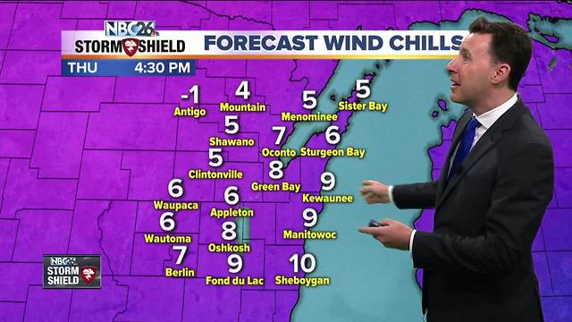
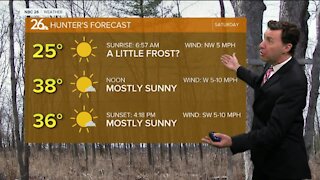
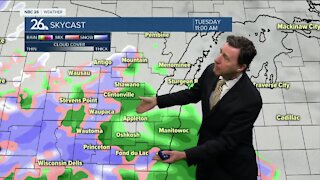
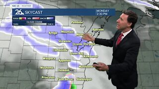
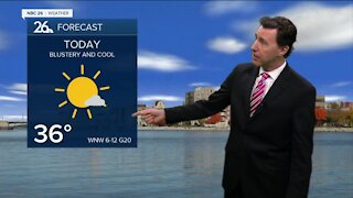
Get ready for a blustery and cold day today behind a strong cold front that has rolled on through. The sun will be coming out, but the temperatures are going to be falling as we head through the afternoon. Basically, you'll feel a taste of winter. The "mildest" temps of the day will be this morning before falling into the lower 20s by late afternoon. Wind chills will be dropping into the single digits in spots. Tonight is going to be a cold, breezy night. Our temperatures may get down to near record lows with a forecasted low of 12 degrees in Green Bay. The record low for Friday is 12 set back in 1933. It'll be close. Friday will be cold with clouds increasing late in the day. At least we'll have a little less wind. Highs will struggle to make it to 30. Late Friday night as a system approaches, we could see some light snow develop, but as of now, it looks like most of that should be mainly to the north, and though there may be some accumulation, it should be fairly light. Lows will be in the low-20s, before rising overnight. Saturday, some folks could see some snow, while others may start mixing in rain. Either way, some accumulation is possible, but it's much too early to be putting any sort of numbers on this system. As of this writing, it does NOT look major, and most of the accumulation should be well to the north again. Highs will be in the mid-30s. Saturday night on the backside of the departing system, we could see a little light snow, but any accumulation would be minor, if anything. As of right now, most of Sunday looks dry, but there's a slight chance of folks farther south to see a rain or snow shower.
-
 1:45
1:45
WGBA
1 year agoStudents excited to start at "huge and beautiful" Vel Phillips Middle School
282 -
 2:28
2:28
WGBA
4 years agoMichael Fish's NBC 26 weather forecast
2 -
 2:32
2:32
WGBA
4 years agoMichael Fish's NBC 26 weather forecast
2 -
 2:47
2:47
WGBA
4 years agoMichael Fish's NBC 26 weather forecast
5 -
 2:08
2:08
WGBA
4 years agoMichael Fish's NBC 26 weather forecast
7 -
 2:42
2:42
WGBA
4 years agoMichael Fish's NBC 26 weather forecast
3 -
 2:40
2:40
WGBA
4 years agoMichael Fish's NBC 26 weather forecast
4 -
 2:33
2:33
WGBA
4 years agoMichael Fish's NBC 26 weather forecast
2 -
 2:42
2:42
WGBA
4 years agoMichael Fish's NBC 26 weather forecast
4 -
 2:13
2:13
WGBA
4 years agoMichael Fish's NBC 26 weather forecast
3