New Hazard Map Extends Danger Zone, Iceland Grindavik Hagafell Fagradalsfjall Litli-Hrútur Volcano
1 year ago
35
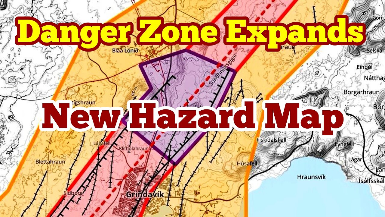
The Icelandic Meteorological Office has updated the hazard assessment map for the area around Grindavík and Svartsengi. With the new map, the danger zone is expanded from what it was before.
The announcement states that the map is based on new satellite images of Svartsengi and the magma tunnel, together with data that was discussed this morning with civil protection, experts from the Meteorological Office and the University of Iceland.
There are three danger zones as can be seen on the map above.
In the announcement, it is stated that the public defense and the police chief in Suðurnes have taken the map into consideration in planning for the area.
https://www.mbl.is/frettir/innlent/2023/11/20/nytt_kort_haettusvaedid_staekkar/
Loading comments...
-
 4:22:25
sophiesnazz
4 hours agoLETS TALK ABOUT BO7 !socials !specs
3.18K -
 1:27:30
Redacted News
4 hours ago"There will be consequences!!!" Trump issues big threat to Putin ahead of peace summit | Redacted
86.8K144 -
 LIVE
LIVE
Amish Zaku
2 hours agoWar Thunder - Tank Tuesday
93 watching -
 1:27:05
Kim Iversen
3 hours agoIsrael DEMANDS X Remove Posts and X COMPLIES | Socialist Groceries Coming To A Store Near You!
40.9K89 -
 1:11:53
vivafrei
11 hours agoThe Great Replacement of American Truckers With Unskilled Foreign Labor - Live with Gord Magill
93.5K63 -
 1:05:13
Sarah Westall
4 hours agoEU Falling, United States Barely Hanging on - Strength and Courage Needed to Fight for Free Speech
39.1K3 -
 LIVE
LIVE
LFA TV
12 hours agoLFA TV ALL DAY STREAM - TUESDAY 8/19/25
797 watching -
 2:11:18
The Quartering
6 hours agoToday's Breaking News! Disgusting Grocery Shopping "Haul" Goes Viral, Las Vegas Collapse & More
112K34 -
 5:43:27
StoneMountain64
7 hours agoBest Extraction shooter is FINALLY on Console (+CoD Reveal Today)
59.8K -
 3:04:51
Due Dissidence
9 hours agoZelensky RETURNS To DC, HUGE Protests In Israel, Gal Gadot Blames Palestine For Flop, MSNBC Rebrands
49.6K27