Volcano Eruption from the International Space Station
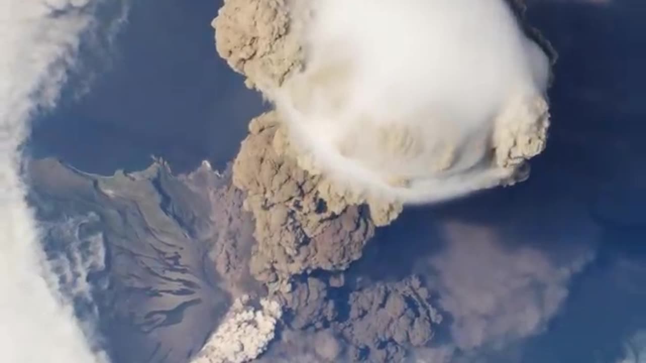
On June 12, 2009, a fortuitous orbit of the International Space Station (ISS) made it possible for an astronaut on board to capture Sarychev Volcano in the early stages of eruption. The volcano is located on the northwestern end of Matua Island, which is part of the Kuril Islands, a chain of 56 islands northeast of Japan. The eruption sent a plume of brown-colored ash and white steam rising into the atmosphere. The plume was so immense that it cast a large shadow on the island. Sarychev is one of the most active volcanoes in the Kuril Island chain. Prior to June 12, the last explosive eruption occurred in 1989, with eruptions in 1986, 1976, 1954, and 1946 also producing lava flows. Watch the video to see how the eruption looked from space. A fortuitous orbit of the International Space Station allowed the astronauts this striking view of Sarychev Volcano (Kuril Islands, northeast of Japan) in an early stage of eruption on June 12, 2009. Sarychev Peak is one of the most active volcanoes in the Kuril Island chain, and it is located on the northwestern end of Matua Island. For more info: http://earthobservatory.nasa.gov/IOTD/view.php?id=38985 http://eol.jsc.nasa.gov/ http://earthobservatory.nasa.gov/ This video can be freely shared and downloaded at https://svs.gsfc.nasa.gov/11446. While the video in its entirety can be shared without permission, the music and some individual imagery may have been obtained through permission and may not be excised or remixed in other products. Specific details on such imagery may be found here: https://svs.gsfc.nasa.gov/11446. For more information on NASA’s media guidelines, visitOn June 12, 2009, a fortuitous orbit of the International Space Station (ISS) made it possible for an astronaut on board to capture Sarychev Volcano in the early stages of eruption. The volcano is located on the northwestern end of Matua Island, which is part of the Kuril Islands, a chain of 56 islands northeast of Japan. The eruption sent a plume of brown-colored ash and white steam rising into the atmosphere. The plume was so immense that it cast a large shadow on the island. Sarychev is one of the most active volcanoes in the Kuril Island chain. Prior to June 12, the last explosive eruption occurred in 1989, with eruptions in 1986, 1976, 1954, and 1946 also producing lava flows. Watch the video to see how the eruption looked from space. A fortuitous orbit of the International Space Station allowed the astronauts this striking view of Sarychev Volcano (Kuril Islands, northeast of Japan) in an early stage of eruption on June 12, 2009. Sarychev Peak is one of the most active volcanoes in the Kuril Island chain, and it is located on the northwestern end of Matua Island. For more info: http://earthobservatory.nasa.gov/IOTD/view.php?id=38985 http://eol.jsc.nasa.gov/ http://earthobservatory.nasa.gov/ This video can be freely shared and downloaded at https://svs.gsfc.nasa.gov/11446. While the video in its entirety can be shared without permission, the music and some individual imagery may have been obtained through permission and may not be excised or remixed in other products. Specific details on such imagery may be found here: https://svs.gsfc.nasa.gov/11446. For more information on NASA’s media guidelines, visitOn June 12, 2009, a fortuitous orbit of the International Space Station (ISS) made it possible for an astronaut on board to capture Sarychev Volcano in the early stages of eruption. The volcano is located on the northwestern end of Matua Island, which is part of the Kuril Islands, a chain of 56 islands northeast of Japan. The eruption sent a plume of brown-colored ash and white steam rising into the atmosphere. The plume was so immense that it cast a large shadow on the island. Sarychev is one of the most active volcanoes in the Kuril Island chain. Prior to June 12, the last explosive eruption occurred in 1989, with eruptions in 1986, 1976, 1954, and 1946 also producing lava flows. Watch the video to see how the eruption looked from space. A fortuitous orbit of the International Space Station allowed the astronauts this striking view of Sarychev Volcano (Kuril Islands, northeast of Japan) in an early stage of eruption on June 12, 2009. Sarychev Peak is one of the most active volcanoes in the Kuril Island chain, and it is located on the northwestern end of Matua Island. For more info: http://earthobservatory.nasa.gov/IOTD/view.php?id=38985 http://eol.jsc.nasa.gov/ http://earthobservatory.nasa.gov/ This video can be freely shared and downloaded at https://svs.gsfc.nasa.gov/11446. While the video in its entirety can be shared without permission, the music and some individual imagery may have been obtained through permission and may not be excised or remixed in other products. Specific details on such imagery may be found here: https://svs.gsfc.nasa.gov/11446. For more information on NASA’s media guidelines, visitOn June 12, 2009, a fortuitous orbit of the International Space Station (ISS) made it possible for an astronaut on board to capture Sarychev Volcano in the early stages of eruption. The volcano is located on the northwestern end of Matua Island, which is part of the Kuril Islands, a chain of 56 islands northeast of Japan. The eruption sent a plume of brown-colored ash and white steam rising into the atmosphere. The plume was so immense that it cast a large shadow on the island. Sarychev is one of the most active volcanoes in the Kuril Island chain. Prior to June 12, the last explosive eruption occurred in 1989, with eruptions in 1986, 1976, 1954, and 1946 also producing lava flows. Watch the video to see how the eruption looked from space. A fortuitous orbit of the International Space Station allowed the astronauts this striking view of Sarychev Volcano (Kuril Islands, northeast of Japan) in an early stage of eruption on June 12, 2009. Sarychev Peak is one of the most active volcanoes in the Kuril Island chain, and it is located on the northwestern end of Matua Island. For more info: http://earthobservatory.nasa.gov/IOTD/view.php?id=38985 http://eol.jsc.nasa.gov/ http://earthobservatory.nasa.gov/ This video can be freely shared and downloaded at https://svs.gsfc.nasa.gov/11446. While the video in its entirety can be shared without permission, the music and some individual imagery may have been obtained through permission and may not be excised or remixed in other products. Specific details on such imagery may be found here: https://svs.gsfc.nasa.gov/11446. For more information on NASA’s media guidelines, visitOn June 12, 2009, a fortuitous orbit of the International Space Station (ISS) made it possible for an astronaut on board to capture Sarychev Volcano in the early stages of eruption. The volcano is located on the northwestern end of Matua Island, which is part of the Kuril Islands, a chain of 56 islands northeast of Japan. The eruption sent a plume of brown-colored ash and white steam rising into the atmosphere. The plume was so immense that it cast a large shadow on the island. Sarychev is one of the most active volcanoes in the Kuril Island chain. Prior to June 12, the last explosive eruption occurred in 1989, with eruptions in 1986, 1976, 1954, and 1946 also producing lava flows. Watch the video to see how the eruption looked from space. A fortuitous orbit of the International Space Station allowed the astronauts this striking view of Sarychev Volcano (Kuril Islands, northeast of Japan) in an early stage of eruption on June 12, 2009. Sarychev Peak is one of the most active volcanoes in the Kuril Island chain, and it is located on the northwestern end of Matua Island. For more info: http://earthobservatory.nasa.gov/IOTD/view.php?id=38985 http://eol.jsc.nasa.gov/ http://earthobservatory.nasa.gov/ This video can be freely shared and downloaded at https://svs.gsfc.nasa.gov/11446. While the video in its entirety can be shared without permission, the music and some individual imagery may have been obtained through permission and may not be excised or remixed in other products. Specific details on such imagery may be found here: https://svs.gsfc.nasa.gov/11446. For more information on NASA’s media guidelines, visitOn June 12, 2009, a fortuitous orbit of the International Space Station (ISS) made it possible for an astronaut on board to capture Sarychev Volcano in the early stages of eruption. The volcano is located on the northwestern end of Matua Island, which is part of the Kuril Islands, a chain of 56 islands northeast of Japan. The eruption sent a plume of brown-colored ash and white steam rising into the atmosphere. The plume was so immense that it cast a large shadow on the island. Sarychev is one of the most active volcanoes in the Kuril Island chain. Prior to June 12, the last explosive eruption occurred in 1989, with eruptions in 1986, 1976, 1954, and 1946 also producing lava flows. Watch the video to see how the eruption looked from space. A fortuitous orbit of the International Space Station allowed the astronauts this striking view of Sarychev Volcano (Kuril Islands, northeast of Japan) in an early stage of eruption on June 12, 2009. Sarychev Peak is one of the most active volcanoes in the Kuril Island chain, and it is located on the northwestern end of Matua Island. For more info: http://earthobservatory.nasa.gov/IOTD/view.php?id=38985 http://eol.jsc.nasa.gov/ http://earthobservatory.nasa.gov/ This video can be freely shared and downloaded at https://svs.gsfc.nasa.gov/11446. While the video in its entirety can be shared without permission, the music and some individual imagery may have been obtained through permission and may not be excised or remixed in other products. Specific details on such imagery may be found here: https://svs.gsfc.nasa.gov/11446. For more information on NASA’s media guidelines, visitOn June 12, 2009, a fortuitous orbit of the International Space Station (ISS) made it possible for an astronaut on board to capture Sarychev Volcano in the early stages of eruption. The volcano is located on the northwestern end of Matua Island, which is part of the Kuril Islands, a chain of 56 islands northeast of Japan. The eruption sent a plume of brown-colored ash and white steam rising into the atmosphere. The plume was so immense that it cast a large shadow on the island. Sarychev is one of the most active volcanoes in the Kuril Island chain. Prior to June 12, the last explosive eruption occurred in 1989, with eruptions in 1986, 1976, 1954, and 1946 also producing lava flows. Watch the video to see how the eruption looked from space. A fortuitous orbit of the International Space Station allowed the astronauts this striking view of Sarychev Volcano (Kuril Islands, northeast of Japan) in an early stage of eruption on June 12, 2009. Sarychev Peak is one of the most active volcanoes in the Kuril Island chain, and it is located on the northwestern end of Matua Island. For more info: http://earthobservatory.nasa.gov/IOTD/view.php?id=38985 http://eol.jsc.nasa.gov/ http://earthobservatory.nasa.gov/ This video can be freely shared and downloaded at https://svs.gsfc.nasa.gov/11446. While the video in its entirety can be shared without permission, the music and some individual imagery may have been obtained through permission and may not be excised or remixed in other products. Specific details on such imagery may be found here: https://svs.gsfc.nasa.gov/11446. For more information on NASA’s media guidelines, visitOn June 12, 2009, a fortuitous orbit of the International Space Station (ISS) made it possible for an astronaut on board to capture Sarychev Volcano in the early stages of eruption. The volcano is located on the northwestern end of Matua Island, which is part of the Kuril Islands, a chain of 56 islands northeast of Japan. The eruption sent a plume of brown-colored ash and white steam rising into the atmosphere. The plume was so immense that it cast a large shadow on the island. Sarychev is one of the most active volcanoes in the Kuril Island chain. Prior to June 12, the last explosive eruption occurred in 1989, with eruptions in 1986, 1976, 1954, and 1946 also producing lava flows. Watch the video to see how the eruption looked from space. A fortuitous orbit of the International Space Station allowed the astronauts this striking view of Sarychev Volcano (Kuril Islands, northeast of Japan) in an early stage of eruption on June 12, 2009. Sarychev Peak is one of the most active volcanoes in the Kuril Island chain, and it is located on the northwestern end of Matua Island. For more info: http://earthobservatory.nasa.gov/IOTD/view.php?id=38985 http://eol.jsc.nasa.gov/ http://earthobservatory.nasa.gov/ This video can be freely shared and downloaded at https://svs.gsfc.nasa.gov/11446. While the video in its entirety can be shared without permission, the music and some individual imagery may have been obtained through permission and may not be excised or remixed in other products. Specific details on such imagery may be found here: https://svs.gsfc.nasa.gov/11446. For more information on NASA’s media guidelines, visitOn June 12, 2009, a fortuitous orbit of the International Space Station (ISS) made it possible for an astronaut on board to capture Sarychev Volcano in the early stages of eruption. The volcano is located on the northwestern end of Matua Island, which is part of the Kuril Islands, a chain of 56 islands northeast of Japan. The eruption sent a plume of brown-colored ash and white steam rising into the atmosphere. The plume was so immense that it cast a large shadow on the island. Sarychev is one of the most active volcanoes in the Kuril Island chain. Prior to June 12, the last explosive eruption occurred in 1989, with eruptions in 1986, 1976, 1954, and 1946 also producing lava flows. Watch the video to see how the eruption looked from space. A fortuitous orbit of the International Space Station allowed the astronauts this striking view of Sarychev Volcano (Kuril Islands, northeast of Japan) in an early stage of eruption on June 12, 2009. Sarychev Peak is one of the most active volcanoes in the Kuril Island chain, and it is located on the northwestern end of Matua Island. For more info: http://earthobservatory.nasa.gov/IOTD/view.php?id=38985 http://eol.jsc.nasa.gov/ http://earthobservatory.nasa.gov/ This video can be freely shared and downloaded at https://svs.gsfc.nasa.gov/11446. While the video in its entirety can be shared without permission, the music and some individual imagery may have been obtained through permission and may not be excised or remixed in other products. Specific details on such imagery may be found here: https://svs.gsfc.nasa.gov/11446. For more information on NASA’s media guidelines, visitOn June 12, 2009, a fortuitous orbit of the International Space Station (ISS) made it possible for an astronaut on board to capture Sarychev Volcano in the early stages of eruption. The volcano is located on the northwestern end of Matua Island, which is part of the Kuril Islands, a chain of 56 islands northeast of Japan. The eruption sent a plume of brown-colored ash and white steam rising into the atmosphere. The plume was so immense that it cast a large shadow on the island. Sarychev is one of the most active volcanoes in the Kuril Island chain. Prior to June 12, the last explosive eruption occurred in 1989, with eruptions in 1986, 1976, 1954, and 1946 also producing lava flows. Watch the video to see how the eruption looked from space. A fortuitous orbit of the International Space Station allowed the astronauts this striking view of Sarychev Volcano (Kuril Islands, northeast of Japan) in an early stage of eruption on June 12, 2009. Sarychev Peak is one of the most active volcanoes in the Kuril Island chain, and it is located on the northwestern end of Matua Island. For more info: http://earthobservatory.nasa.gov/IOTD/view.php?id=38985 http://eol.jsc.nasa.gov/ http://earthobservatory.nasa.gov/ This video can be freely shared and downloaded at https://svs.gsfc.nasa.gov/11446. While the video in its entirety can be shared without permission, the music and some individual imagery may have been obtained through permission and may not be excised or remixed in other products. Specific details on such imagery may be found here: https://svs.gsfc.nasa.gov/11446. For more information on NASA’s media guidelines, visitOn June 12, 2009, a fortuitous orbit of the International Space Station (ISS) made it possible for an astronaut on board to capture Sarychev Volcano in the early stages of eruption. The volcano is located on the northwestern end of Matua Island, which is part of the Kuril Islands, a chain of 56 islands northeast of Japan. The eruption sent a plume of brown-colored ash and white steam rising into the atmosphere. The plume was so immense that it cast a large shadow on the island. Sarychev is one of the most active volcanoes in the Kuril Island chain. Prior to June 12, the last explosive eruption occurred in 1989, with eruptions in 1986, 1976, 1954, and 1946 also producing lava flows. Watch the video to see how the eruption looked from space. A fortuitous orbit of the International Space Station allowed the astronauts this striking view of Sarychev Volcano (Kuril Islands, northeast of Japan) in an early stage of eruption on June 12, 2009. Sarychev Peak is one of the most active volcanoes in the Kuril Island chain, and it is located on the northwestern end of Matua Island. For more info: http://earthobservatory.nasa.gov/IOTD/view.php?id=38985 http://eol.jsc.nasa.gov/ http://earthobservatory.nasa.gov/ This video can be freely shared and downloaded at https://svs.gsfc.nasa.gov/11446. While the video in its entirety can be shared without permission, the music and some individual imagery may have been obtained through permission and may not be excised or remixed in other products. Specific details on such imagery may be found here: https://svs.gsfc.nasa.gov/11446. For more information on NASA’s media guidelines, visitOn June 12, 2009, a fortuitous orbit of the International Space Station (ISS) made it possible for an astronaut on board to capture Sarychev Volcano in the early stages of eruption. The volcano is located on the northwestern end of Matua Island, which is part of the Kuril Islands, a chain of 56 islands northeast of Japan. The eruption sent a plume of brown-colored ash and white steam rising into the atmosphere. The plume was so immense that it cast a large shadow on the island. Sarychev is one of the most active volcanoes in the Kuril Island chain. Prior to June 12, the last explosive eruption occurred in 1989, with eruptions in 1986, 1976, 1954, and 1946 also producing lava flows. Watch the video to see how the eruption looked from space. A fortuitous orbit of the International Space Station allowed the astronauts this striking view of Sarychev Volcano (Kuril Islands, northeast of Japan) in an early stage of eruption on June 12, 2009. Sarychev Peak is one of the most active volcanoes in the Kuril Island chain, and it is located on the northwestern end of Matua Island. For more info: http://earthobservatory.nasa.gov/IOTD/view.php?id=38985 http://eol.jsc.nasa.gov/ http://earthobservatory.nasa.gov/ This video can be freely shared and downloaded at https://svs.gsfc.nasa.gov/11446. While the video in its entirety can be shared without permission, the music and some individual imagery may have been obtained through permission and may not be excised or remixed in other products. Specific details on such imagery may be found here: https://svs.gsfc.nasa.gov/11446. For more information on NASA’s media guidelines, visitOn June 12, 2009, a fortuitous orbit of the International Space Station (ISS) made it possible for an astronaut on board to capture Sarychev Volcano in the early stages of eruption. The volcano is located on the northwestern end of Matua Island, which is part of the Kuril Islands, a chain of 56 islands northeast of Japan. The eruption sent a plume of brown-colored ash and white steam rising into the atmosphere. The plume was so immense that it cast a large shadow on the island. Sarychev is one of the most active volcanoes in the Kuril Island chain. Prior to June 12, the last explosive eruption occurred in 1989, with eruptions in 1986, 1976, 1954, and 1946 also producing lava flows. Watch the video to see how the eruption looked from space. A fortuitous orbit of the International Space Station allowed the astronauts this striking view of Sarychev Volcano (Kuril Islands, northeast of Japan) in an early stage of eruption on June 12, 2009. Sarychev Peak is one of the most active volcanoes in the Kuril Island chain, and it is located on the northwestern end of Matua Island. For more info: http://earthobservatory.nasa.gov/IOTD/view.php?id=38985 http://eol.jsc.nasa.gov/ http://earthobservatory.nasa.gov/ This video can be freely shared and downloaded at https://svs.gsfc.nasa.gov/11446. While the video in its entirety can be shared without permission, the music and some individual imagery may have been obtained through permission and may not be excised or remixed in other products. Specific details on such imagery may be found here: https://svs.gsfc.nasa.gov/11446. For more information on NASA’s media guidelines, visitOn June 12, 2009, a fortuitous orbit of the International Space Station (ISS) made it possible for an astronaut on board to capture Sarychev Volcano in the early stages of eruption. The volcano is located on the northwestern end of Matua Island, which is part of the Kuril Islands, a chain of 56 islands northeast of Japan. The eruption sent a plume of brown-colored ash and white steam rising into the atmosphere. The plume was so immense that it cast a large shadow on the island. Sarychev is one of the most active volcanoes in the Kuril Island chain. Prior to June 12, the last explosive eruption occurred in 1989, with eruptions in 1986, 1976, 1954, and 1946 also producing lava flows. Watch the video to see how the eruption looked from space. A fortuitous orbit of the International Space Station allowed the astronauts this striking view of Sarychev Volcano (Kuril Islands, northeast of Japan) in an early stage of eruption on June 12, 2009. Sarychev Peak is one of the most active volcanoes in the Kuril Island chain, and it is located on the northwestern end of Matua Island. For more info: http://earthobservatory.nasa.gov/IOTD/view.php?id=38985 http://eol.jsc.nasa.gov/ http://earthobservatory.nasa.gov/ This video can be freely shared and downloaded at https://svs.gsfc.nasa.gov/11446. While the video in its entirety can be shared without permission, the music and some individual imagery may have been obtained through permission and may not be excised or remixed in other products. Specific details on such imagery may be found here: https://svs.gsfc.nasa.gov/11446. For more information on NASA’s media guidelines, visit
-
 5:35:39
SpartakusLIVE
9 hours agoLAST DAY of BATTLEFIELD 6 || WZ - BF6 - PUBG
39.8K -
 5:28
5:28
Zach Humphries
1 day ago $10.21 earnedMAJOR STELLAR XLM PARTNERSHIP ANNOUNCED!
36.5K2 -
 4:51:51
MattMorseTV
11 hours ago $19.58 earned🔴Gaming Sunday🔴
71.3K12 -
 24:24
24:24
Jasmin Laine
12 hours ago“Their BIGGEST Mistake Yet”—U.S. Officials TORCH Carney in Brutal Report
60.7K65 -
 5:15:53
Rallied
10 hours ago $8.88 earnedWARZONE SOLO CHALLENGES ALL DAY
54.8K -
 2:00:33
Joker Effect
8 hours agoSoo @MrBeast charity, is it legit? XenaTheWitch got attested? Lets talk about it! HOW TO GO VIRAL.
44.4K5 -
 27:01
27:01
TheRoyaltyAutoService
16 hours ago $4.85 earnedAnother Shop Replaced The Timing Belt & Fuel Injectors On This Honda Pilot… Now It Has No Power!
51.3K3 -
 10:14:25
GritsGG
17 hours agoRanked Crim 2! Most Wins 3390+ 🧠
92.7K2 -
 3:12:37
IsaiahLCarter
1 day ago $7.61 earnedJonah O. Wheeler: In Defense of Reality || APOSTATE RADIO #026
52.4K2 -
 9:17:16
Cewpins
12 hours agoSmoke Sesh🔥Gaming???💨420🍃!MJ !giveaway
36.7K14