11 Insanely Dangerous Roads
"From the highest peaks in the Himalayas, to a road that spans 2 continents, these are 11 INSANELY Dangerous Roads !
7.Karakoram Highway
LENGTH - 1,300 km (800mi)
HIGHEST ELEVATION - 15,397ft (4,693m)
LOCATION - China, Pakistan
The unofficial name for this road is the China - Pakistan Friendship Highway, which is kind of cute.
And that's about as nice as this road ever gets, with crazy elevations, sharp turns, and this iconic section, the highway has become somewhat famous online.
If you manage to survive all the dangers of the Himalayas, don’t worry, you can still get blasted by falling rock in the lower parts of the road. Huge boulders rained down the cliffside hitting busses and ruined everybody’s day. It took more than a week to clean everything up and reopen the road.
6.Fairy Meadows Road
LENGTH - 10 km
HIGHEST ELEVATION - 8,000 ft
LOCATION - Pakistan
Speaking of Karakoram Highway, it is important to note, that you can take the wrong exit by mistake and end up on this even CRAZIER road. Don’t let the name fool you, the Fairy Meadows road is filled with twists and turns and no guardrails protecting you from the huge drop.
Most travelers say that no picture or video does this road any justice and that driving through it can sometimes be a once in a lifetime experience.
+BONUS+
I-70 in Colorado
I-70 traverses through America’s Himalayas, otherwise known as The Rockies. Throughout the 2000+ miles this interstate covers, the Glenwood Canyon is probably the most dangerous part. Since the freeway stays open, even in some extreme conditions, driving next to the Colorado River on a windy winter day, you will notice that there is probably more ice than asphalt on the road.
5.Keylong-Kishtwar Road
LENGTH - 145 m (234 km
HIGHEST ELEVATION - 21,460 (6,451m)
LOCATION - Northern India
At this point, you might have figured out that driving through Northern India can be a bit tricky, and here is one more road that proves that.
Yet again, the road is simply carved into the side of the mountain, and no one thought side rails were a good idea. Accidentally looking down into the abyss might be enough to make you pass out, but don’t worry, the water seeping down the face of the mountain is sure to wake you up.
4.Abano Pass
LENGTH - 84.5km
HIGHEST ELEVATION - 9,350 ft (2,850 m)
LOCATION - Georgia
Ahh, a breath of fresh air, or the lack there of because of the high altitude. The Abano pass connects to remote locations in the Caucasus Mountains, it is closed for most of the year, and it cannot be traveled in anything but a 4x4. You should also watch out for avalanches and sudden drops in temperature.
Again, no guard rails.
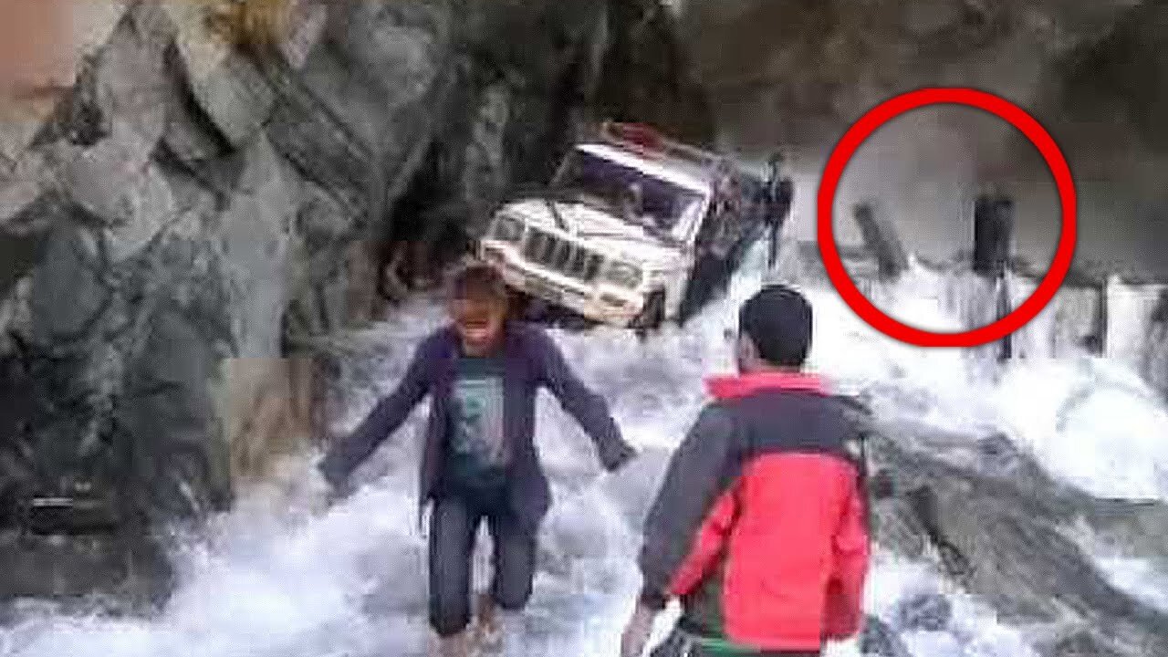
3. Lamjung Road
LENGTH - 60mi (96km)
HIGHEST ELEVATION - 11,545ft (3,519 m)
LOCATION - Nepal
Twists and turns may make you squirm, but a freaking water fall in the middle of the road? At some point, these roads just become ridiculous. And this is that point.
A youtuber caught this amazing footage of his jeep trying to make it through the river, i mean road.
It is really hard to discern between bravery and stupidity sometimes, and choosing to go down this road, in these conditions, is a bit more stupid than brave. Thankfully, the jeep made it out fine, and everyone lived happily ever after.
+BONUS+
Guoliang Tunnel Road, China
This amazing tunnel road carved into the side of a mountain was finished in 1977. Construction started in 1972, and more than 5000 workers, and 4 different government agencies got together to accomplish this marvel…
Just kidding, thirteen villagers from the village of Guoliang sold their livestock to buy hammers and chisels and built this road alone.
2. Bayburt of Yolu- D915
LENGTH - 65 mi (106km)
HIGHEST ELEVATION - 6,677ft (2,035m)
LOCATION - Turkey
Even though this road is short, it has more than 20 steep hairpins that will make you wish you took a plane, or stayed at home.
After the closure of the Road of Death in Bolivia, the Bayburt pass has gained notoriety in extreme driving circles, with many people wanting to attempt the perilous drive.
1.Pan-American Highway
LENGTH - 19,000 mi (30,000km)
HIGHEST ELEVATION - Undecided
LOCATION - North and South America
Many people dream of starting at the Northernmost part of Alaska and driving all the way down to Ushuaia, Argentina.
Alas, it is not possible without taking a ferry in Panama. There is a 40 mile stretch of land that is considered “no mans land” between Panama and Columbia. It is called the Darian Gap, and its a jungle that offers a safe haven for drug traffickers, guerilla fighters, and pesky Jaguars.
If you manage to survive all of that, you also have to worry about the treacherous part known as Dalton Highway that runs through Alaska, you also have to navigate through days of heavy U.S. traffic, insane climbs through the rockies, and hundreds of miles of no service or gas station in sight."
-
 10:17
10:17
World Unearthed
8 months ago7 ABANDONED MILITARY Sites Around The World
83 -
 2:34:20
Barry Cunningham
5 hours agoPRESIDENT TRUMP WELCOMES FOOTBALL SEASON! AND MORE BREAKING NEWS!
34.7K21 -
 LIVE
LIVE
Mally_Mouse
9 hours ago🔥🍺Spicy HYDRATE Saturday!🍺🔥-- Let's Play: Baldur's Gate!
395 watching -
 21:20
21:20
AndresRestart
2 hours ago $0.04 earnedNintendo's GENIUS Mario & Zelda 40th Anniversary Plan!?
1.77K2 -
 LIVE
LIVE
SavageJayGatsby
3 hours agoSpicy Saturday | Let's Play: Baldur's Gate 3 | $300 Spicy Bite Goal | Mallymouse and Gwenifred
101 watching -
 LIVE
LIVE
Rallied
4 hours ago $1.77 earnedSolo Challenges ALL DAY
146 watching -
 2:26:32
BooniesHQ
4 hours agoGame Of SKATE Shaun Hover Vs. Jeff DeChesare: Boonies Skate Night 1
78.5K1 -
 17:08
17:08
Exploring With Nug
1 day ago $1.02 earnedMassive Thunderstorm Hits During Search for Missing Georgia Woman!
7.08K -
 1:00:04
Sgt Wilky Plays
2 hours agoRumble Gaming Bad Company Presents WARZONEPALOOZA
6.64K1 -
![Devin Nunes - Devin Nunes Reveals The Document The [DS] Was Looking For Was Hidden,Truth Is Coming](https://1a-1791.com/video/fww1/20/s8/1/-/e/L/d/-eLdz.0kob-small-Devin-Nunes-Devin-Nunes-Rev.jpg) 1:17:44
1:17:44
X22 Report
8 hours agoDevin Nunes - Devin Nunes Reveals The Document The [DS] Was Looking For Was Hidden,Truth Is Coming
111K117