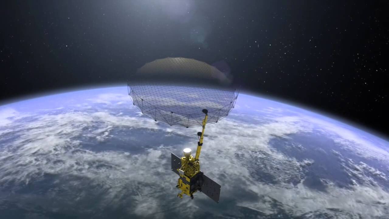
SMAP At Work - NASA's Soil Moisture Active Passive Satellite
The Alaska Satellite Facility is part of the University of Alaska Fairbanks.
---------------------------
NASA's SMAP satellite will measure global soil moisture every three days for three years--including soil's freeze-thaw state. These measurements will be used to:
1) further understanding of processes that link the water, energy, and carbon cycles;
2) enhance weather and climate prediction models;
3) quantify net carbon flux in boreal landscapes; and
4) develop improved flood-prediction and drought-monitoring capabilities.
Observatory: The SMAP spacecraft features an instrument suite deployed by an expendable launch vehicle into a 680-km, near-polar, sun-synchronous orbit, with equator crossings at 6 a.m. and 6 p.m. local time. SMAP provides global coverage within three days at the equator and two days at boreal latitudes.
Instrument: The instrument includes a radiometer and a synthetic aperture radar (SAR), operating at L-band (1.20-1.41 GHz), that measure surface emission and backscatter, sensing soil conditions through moderate vegetation cover.
Operations: SMAP science measurements will be acquired for three years. A comprehensive validation program will be carried out after launch to assess the accuracies of soil-moisture and freeze-thaw estimates. Data products from the SMAP mission will be made available through the Alaska Satellite Facility DAAC and the NSIDC DAAC.
CREDITS
Produced by the Alaska Satellite Facility SAR DAAC
In cooperation with NASA / JPL
Additional material courtesy of Lucas A. Jones, John S. Kimball, Joseph Glassy (University of Montana); National Snow and Ice Data Center DAAC (NSIDC); Earth Science and Remote Sensing Unit, NASA Johnson Space Center; International Geosphere-Biosphere Programme; Globaia; UN Foundation; Ubaldo Fernandez;
-
 2:00:26
MG Show
17 hours agoPresident Trump Making BIG Deals in UK & EU; Structure Change
12.7K14 -
 23:09
23:09
GritsGG
13 hours agoQuad Domination w/ Bobby Poff!
39.7K1 -
 2:03:21
Side Scrollers Podcast
18 hours agoTea App Doxxing DISASTER, “PROBLAMATIC” Sydney Sweeny, INSANE Online “Safety” Act | Side Scrollers
6.74K8 -
 LIVE
LIVE
Lofi Girl
2 years agoSynthwave Radio 🌌 - beats to chill/game to
659 watching -
 1:32:48
Omar Elattar
8 months agoAndy Elliott: "Quit Your Excuses Now!" How to 10x Your Income In 12 Months!
5.06K1 -
 2:02:10
Inverted World Live
8 hours agoGhislaine Maxwell Gives 100 Names to DOJ | Ep. 81
280K29 -
 2:51:11
TimcastIRL
9 hours agoBREAKING: MASS SHOOTING ERUPTS In NYC, Police Officer SHOT, FBI On Scene | Timcast IRL
272K133 -
 14:43:03
ZWOGs
15 hours ago🔴LIVE IN 1440p! - EFT w/ crgoodw1n, Kingdom Come Deliverance, Splitgate 2, & More! - Come Hang Out!
60.8K2 -
 30:09
30:09
Afshin Rattansi's Going Underground
1 day agoCurtis Yarvin: ‘Trump 47 is 10x More Powerful than Trump 45’ & the TOXIC US-Israel Relationship
41.7K34 -
 3:48:08
Drew Hernandez
13 hours agoTRUMP HINTS DEMS COULD HAVE PLANTED FAKE EVIDENCE & MANIPULATED EPSTEIN FILES
74.1K41