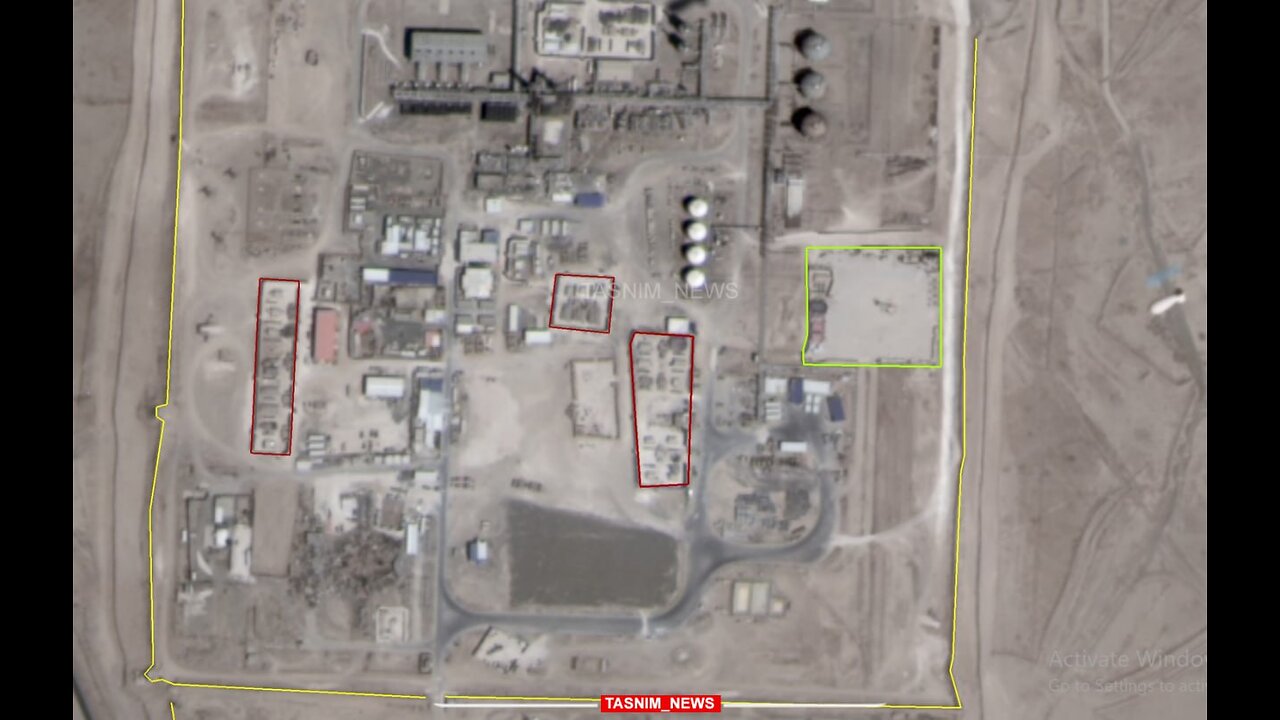
An examination of the satellite images from the Koniko gas field (the largest gas field in Syria)
An examination of the satellite images released from the Koniko gas field (the largest gas field in Syria) shows that the US Army is heavily engaged in new constructions in this area.
According to what can be seen in the satellite images, since about 2 years ago, the construction of numerous military facilities in the Koniko gas field has been increasing, including the construction of a defensive wall (4 km) around this area. He also mentioned the creation of numerous bunkers and military sites in the northern and central part of this gas field.
In addition, since the beginning of last year (2022), a monitoring balloon management center has been established in this gas field, which monitors the area from a height of 4,000 meters above the ground. (Recent satellite images are at the moment the balloon was photographed at a height of 1,200 meters above the ground.)
Based on satellite images, it seems that 6 military sites have been created within the 100-hectare area of Koniko Square, and their location and arrangement changes from time to time.
According to the information received by Tasnim, private American companies, as operators of remote sensing satellites, take pictures of this area almost permanently and at least once a week.
-
 1:48:16
Tucker Carlson
2 hours agoCliffe Knechtle Answers Tough Questions About the Bible, Demons, Israel, Judas, Free Will, and Death
64.4K114 -
 LIVE
LIVE
Viss
3 hours ago🔴LIVE - How To Winner Winner Chicken Dinner! - PUBG
148 watching -
 1:00:41
Timcast
4 hours agoTrump MOBILIZING National Guard In NATIONWIDE Crackdown
122K145 -
 1:06:02
Sean Unpaved
3 hours agoQuarterbacks, Coaches, & Contracts: Sanders' Draft Drama, Meyer vs. Harbaugh, & McLaurin's Big Deal
27.8K1 -
 2:11:45
Steven Crowder
6 hours agoDonald Trump Vs American Crime: Chicago is Next & Libs Are Freaking Out
299K301 -
 41:08
41:08
Grant Stinchfield
2 hours ago $1.49 earnedDemocrats Try to Turn California Into Predator Playground with Proposed "Child Predator Dream Bill"
16.7K2 -
 1:21:06
Rebel News
3 hours agoCdn troops in Ukraine? Poilievre backs self-defence, Hamas thugs cancel Ottawa Pride | Rebel Roundup
18.3K21 -
 24:58
24:58
Neil McCoy-Ward
3 hours ago⚠️ OUTRAGE! What They Just Announced For YOUR HOME!!! 🚨
26K15 -
 LIVE
LIVE
IrishBreakdown
4 hours agoNotre Dame and Miami Set To Reignite Intense Rivalry
212 watching -
 1:57:07
The Charlie Kirk Show
3 hours agoChicago Next! + The Blue Slip Problem | Sen. Tuberville, Alex Clark | 8.25.2025
63.7K21