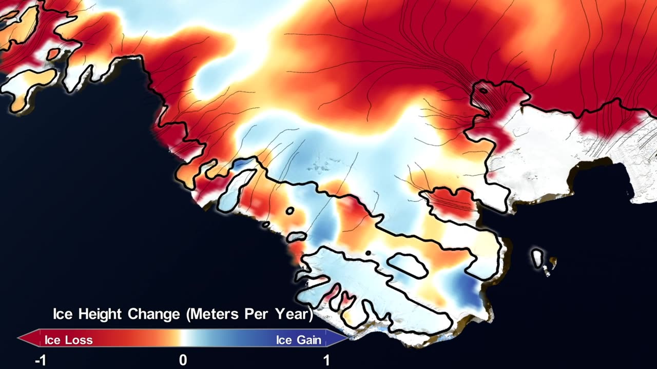
Charting the Frozen Frontier: NASA's Mission Maps 16 Years of Ice Loss 🌊
Embark on an icy odyssey through time and space as we unveil NASA's remarkable mission to map 16 years of ice loss in our video, "Charting the Frozen Frontier: NASA's Mission Maps 16 Years of Ice Loss 🌊🛰️."
In this video, we'll guide you through the groundbreaking endeavor of monitoring Earth's changing ice sheets and glaciers, a mission vital for understanding the impacts of climate change. Through captivating visuals and expert insights, you'll witness the science and wonder behind this critical research.
Delve into the significance of tracking ice loss, its implications for sea-level rise, and the cutting-edge technology that makes it possible. Gain a deeper appreciation for the dedication and innovation driving NASA's commitment to understanding our planet.
This video is your portal to the forefront of Earth science, where NASA's missions provide invaluable data to address some of our planet's most pressing challenges. Subscribe now to stay connected with the latest findings about ice loss and continue your journey through the wonders of Earth and beyond. 🌊🌍🔭
#NASA #IceLossMapping #EarthScience #ClimateChange #SatelliteObservations #ScientificDiscovery #GlacialResearch #EnvironmentalMonitoring #SpaceExploration
-

Redacted News
2 hours agoArrest Hillary Clinton!?! Here we go! | Redacted News Live
100K57 -
 LIVE
LIVE
Kimberly Guilfoyle
2 hours ago"Burns Bags" at FBI, What's Next? Interview with Former Agent John Nantz | Ep242
593 watching -
 LIVE
LIVE
RalliedLIVE
1 day ago $2.89 earnedBattlefield 6 REVEAL w/ Ral
644 watching -
 44:45
44:45
The White House
2 hours agoPresident Trump Signs an Executive Order, July 31, 2025
13.5K14 -
 LIVE
LIVE
Sarah Westall
1 hour ago“This Conversation Would Land Me in Prison in Ireland” - Its the Global Plan w/ Captain Kieran Kelly
389 watching -
 1:15:42
vivafrei
3 hours agoPelosi Doth Protest Too Much! "Trans" Athlete Plot to Harm Female? Crooked hillary Cooked & MORE
87.4K24 -
 1:42:17
The Quartering
5 hours agoHillary Clinton FINALLY BUSTED, Nancy Pelosi MELTDOWN, Kamala Harris Admits Defeat & More
116K72 -
 3:10:42
Barry Cunningham
9 hours agoMUST SEE: KAROLINE LEAVITT HOSTS WHITE HOUSE PRESS CONFERENCE ( AND MORE NEWS)
57.6K24 -
 53:03
53:03
Sean Unpaved
6 hours agoSchlereth Unplugged: 3x Champ Talks TV, Football, & 2025 Season Expectations
42.7K1 -
 1:03:28
Russell Brand
6 hours agoCan You Really Take an Unbiased Look at Hitler? - SF624
151K122