Earth at Night
1 year ago
2
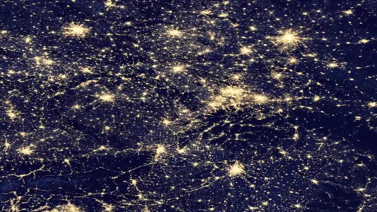
This view of Earth at night is a cloud-free view from space as acquired by the Suomi National Polar-orbiting Partnership Satellite (Suomi NPP). A joint program by NASA and NOAA, Suomi NPP captured this nighttime image with the satellite's Visible Infrared Imaging Radiometer Suite (VIIRS). The day-night band on VIIRS detects light in a range of wavelengths from green to near-infrared and uses filtering techniques to observe signals such as city lights, gas flares, and wildfires. This new image is a composite of data acquired over nine April days and thirteen October 2012. It took 312 satellite orbits and 2.5 terabytes of data to get a clear shot of every parcel of land surface.
Loading comments...
-
 14:39
14:39
Talk Nerdy Sports - The Ultimate Sports Betting Podcast
58 minutes ago3/24/25 - 8 Bets to Slap the Books – March 24th Madness with Vas & Riste
-
 1:18:03
Sean Unpaved
4 hours agoMarch Madness Weekend Recap! Who Made It? Who Didn't?
45K1 -
 49:02
49:02
The White House
3 hours agoPresident Trump and the Governor of Louisiana Deliver Remarks
22.4K11 -
 15:39
15:39
T-SPLY
5 hours agoDemocrats Are Shocked to Find Out Americans Want Deportations
15.7K29 -
 1:02:58
Kyle Fortch
7 hours ago $0.49 earnedHeather Richardson: Proving Yourself As a Female On Tour, Netflix Secrets | THE ONE SHEET S1E9
18.7K4 -
 1:03:19
Timcast
4 hours agoMan DRIVES CAR Into Tesla Protesters, ARRESTED & Charged, DOJ THREATENS Arrestsc VIOLENCE Escalates
300K342 -
 43:33
43:33
CryptoWendyO
2 hours ago $1.58 earnedPREPARE FOR XRP’S NEXT BIG MOVE (3 HUGE ANNOUNCEMENTS)
27.3K1 -
 1:53:30
Steven Crowder
7 hours agoHow Rogue Judges Are Destroying MAGA & How Trump Can Stop Them
619K440 -
 1:30:41
Benny Johnson
5 hours ago🚨PANIC: DOJ Moves To LOCK-UP The Squad! Terrorism Charges For Libs | Snow White BOMBS, Trump Curse
131K212 -
 1:08:49
Flyover Conservatives
15 hours agoSchumer, Newsom, AOC & Bernie: Is this the Collapse of the Democrat Party?; Economic Update - Dr. Kirk Elliott | FOC Show
61.8K4