NASA | Greenland's Ice Layers Mapped in 3D
1 year ago
8
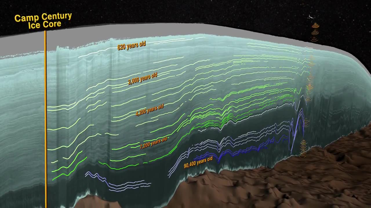
Peering into the thousands of frozen layers inside Greenland’s ice sheet is like looking back in time. Each layer provides a record of not only snowfall and melting events, but what the Earth’s climate was like at the dawn of civilization, or during the last ice age, or during an ancient period of warmth similar to the one we are experiencing today. Using radar data from NASA’s Operation IceBridge, scientists have built the first-ever comprehensive map of the layers deep inside the ice sheet.
Loading comments...
-
 LIVE
LIVE
Edge of Wonder
3 hours ago4 Alien Species Revealed by Congressman & AI Creates ‘New Physics’
329 watching -
 LIVE
LIVE
Mally_Mouse
21 hours agoFriend Friday!! 🎉 - Let's Play! - Goose Goose Duck
102 watching -
 LIVE
LIVE
Spartan
1 hour agoRanked + Octopath Traveler 2
40 watching -
 LIVE
LIVE
GrimmHollywood
8 hours ago🔴LIVE • GRIMM HOLLYWOOD • RUMBLE SPARTANS HALO NIGHT • GRIMMDY GAMES • NEW GRIMM FILM
84 watching -
 43:26
43:26
BonginoReport
9 hours agoThe Future Is Bright w/ GOP Youth Advisory Chair CJ Pearson - Hayley Caronia (Ep.118)
67.2K18 -
 LIVE
LIVE
MissesMaam
1 hour ago*Spicy Sips* Friend Friday with Mally_Mouse and Friends!!! 💚✨
86 watching -
 LIVE
LIVE
ZWOGs
4 hours ago🔴LIVE IN 1440p! - Games w/ Maam, Kingdom Come Deliverance, & More - Come Hang Out!
18 watching -
 1:17:08
Kim Iversen
3 hours agoNetanyahu Declares WAR On Algorithms | Zionists Demand Megyn Kelly's Head
38.7K111 -
 LIVE
LIVE
Nerdrotic
4 hours ago $0.43 earnedDisney HATES YOU! But Needs You, James Gunn's Peacemaker, Alien: Earth | Friday Night Tights 368
1,530 watching -
 LIVE
LIVE
Quite Frankly
6 hours ago"Antichrist Summit, Cracker Barrel Syndrome, Friday Extras" ft Matt 8/22/25
502 watching