SWOT: Earth Science Satellite Will Help Communities Plan for a Better Future
SWOT: Earth Science Satellite Will Help Communities Plan for a Better Future
41K views · 10 months ago...more
NASA Jet Propulsion Laboratory
1.17M
Subscribe
452
Share
Save
Report
Comments34
God_Ozai
Flat earthers be like huh I didn’t see that it’s fake….
Up next
1:14
SpaceX - NASA - SWOT - Surface Water and Ocean Topography Rocket Launch Information
Space Launch Schedule•1.3K views
9:06
NASA's Voyager 1 Detects Strange Sound from Space
Zem TV•2.4M views
5:07
Raakhi Ke Din Vaada Karo (Video Song) - Pyari Behna
Bollywood Retro•60K views
49:32
Bulldogs Behind the Scenes: Large Lakes Observatory
UMD Alumni Relations•171 views
53:32
Our Planet | Frozen Worlds | FULL EPISODE | Netflix
Netflix•30M views
58:00
UTIG Seminar Series: Dallas Sherman, University of Texas Institute for Geophysics
University of Texas Institute for Geophysics
New
80 views
7:23
"A Voyage to Mars" Amazing Landing System by Nasa's Curiosity Rover Mission to Mars this August
Salar Golestanian•15K views
28:58
HOW IT WORKS: The International Space Station
DOCUMENTARY TUBE•109M views
3:30
I Jumped From Space (World Record Supersonic Freefall)
Red Bull•14M views
19:06
Surface Water and Ocean Topography (SWOT)
NASA Climate Change•1.4K views
8:42
ISS Tour: Kitchen, Bedrooms & The Latrine
VideoFromSpace•5.7M views
1:40
How Gravity Works - GRACE Mission
Oldboy Graphics•89 views
Description
SWOT: Earth Science Satellite Will Help Communities Plan for a Better Future
NASA Jet Propulsion Laboratory
452
Likes
41,208
Views
Oct 27
2022
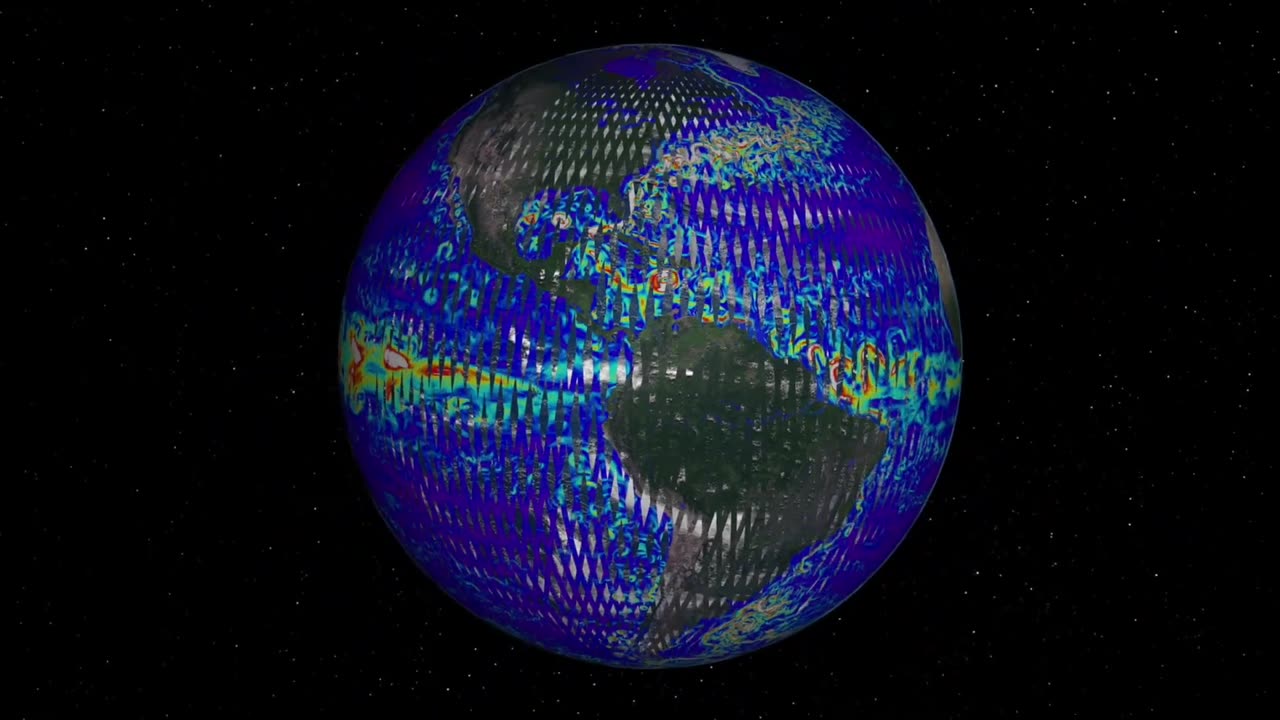
A new Earth science mission, led by NASA and the French space agency Centre National d’Études Spatiales (CNES), will help communities plan for a better future by surveying the planet’s salt and freshwater bodies. The Surface Water and Ocean Topography (SWOT) mission will measure the height of water in lakes, rivers, reservoirs, and the oceans.
As climate change accelerates the water cycle, more communities around the world will be inundated with water while others won’t have enough. SWOT data will be used to improve flood forecasts and monitor drought conditions, providing essential information to water management agencies, civil engineers, universities, the U.S. Department of Defense, disaster preparedness agencies, and others who need to track water in their local areas. In this video, examples of how SWOT data will be used in these communities are shared by a National Weather Service representative in Oregon, an Alaska Department of Transportation engineer, researchers from the University of Oregon and University of North Carolina, a NASA Jet Propulsion Laboratory scientist working with the Department of Defense, and a JPL scientist working with the Louisiana Coastal Protection and Restoration Agency.
:30 - Flood Watches & Warnings - Portland, Oregon
1:08 - Water Management - Fern Ridge Lake, Oregon
2:05 - Protecting Infrastructure - Alaska
2:54 - National Security - Department of Defense
3:24 - Coastal Protection - Mississippi River Delta
SWOT is expected to launch from Vandenberg Space Force Base in California in December 2022.
The mission is a collaboration between NASA and CNES, with contributions from the Canadian Space Agency and UK Space Agency. JPL, which is managed for NASA by Caltech in Pasadena, California, leads the U.S. component of the project.
To learn more about the mission, visit: https://swot.jpl.nasa.gov/
Credit: NASA/JPL-Caltech/CNES/Thales Alenia Space
-
 2:34:32
Badlands Media
5 days agoCODEX 9/11
253K205 -
 1:53:43
Nerdrotic
6 hours ago $0.27 earnedMysteries of 3I/ATLAS | Forbidden Frontier #113
35.1K4 -
 2:04:21
vivafrei
1 day agoEp. 278: D.C. Peace Wave! Big Tish & Nipple Judge SPANKED! "Maryland Man" Trafficker FREE & MORE?
79.1K106 -
 LIVE
LIVE
Damysus Gaming
2 hours agoBorderlands 3 - Part 8 - FL4K Time | Children of the Vault be Warned!
51 watching -
 1:30:28
Patriots With Grit
5 hours agoWhat You Should Know About Harmful Vaccine Ingredients And What To Say To Your Doctor, Pediatrician, Health Department or School When They Pressure You, Your Kids Or Your Family Members | Dr. Bryan Ardis, D.C.
6.98K5 -
 LIVE
LIVE
This is the Ray Gaming
1 hour ago $0.01 earnedSunday Night Live with the Boys | Rumble Premium Creator
35 watching -
 2:02:16
ItsMossy
2 hours ago🍃NEW MIC WHO THIS🍃DRIVING SIM GO BRRR🍃420 SESH🍃
2.06K1 -
 LIVE
LIVE
THOUGHTCAST With Jeff D.
2 hours agoSunday night Fortnite With ScottishVikingGaming & crew
26 watching -

a12cat34dog
3 hours agoSOLID DAWG RETURNS :: METAL GEAR SOLID :: 1998 IS UNFORGIVING {18+}
5.7K1 -
 4:02:55
yellow_1ron
4 hours agoGAMING WITH THE HOMIES JOIN UP | JOIN!
7.07K